Monday, July 27, 2015

More Gold Country-- 7/27/2015

We were able to take a day trek to Gold Country on our final summer trip to Stockton.  Our first two plaques were right across the street from each other-- which makes life so much easier :)
El Dorado (Originally Mud Springs) CHL 486 was the first plaque we saw.  El Dorado was a camp on the Carson Emigrant Trail and a gold mining town in the mid-1850s.
Across the street we came to the El Dorado-Nevada House (Mud Springs)- Overland Pony Express Route in California (CHL 700).  This station was an important remount stop on the Pony Express and William (Sam) Hamilton stopped here carrying the first westbound mail from Missouri to Sacramento. 
Next we moved on to Old Dry Diggins- Old Hangtown- Placerville (CHL 475).  That's a great deal of synonyms for one very quaint little town!
This was a very rich mining camp and the terminus of the Comstock Lode.  
According to the state, "John M. Studebaker, Mark Hopkins, Leland Stanford, Phillip Armour, and Edwin Markham were among well-known men who contributed to Placerville's history, as did John A. 'Snowshoe' Thompson, who carried from 60 to 80 pounds of mail on skis from Placerville over the Sierra to Carson Valley during winter months."
Our next stop creeped Libi out!

It's a good thing that we couldn't see much due to the building being under construction the Hangman's Tree (CHL 141).
The stump of the hangman's tree is actually located under this building!
This helps to explain one of Placerville's many names-- Hangtown.  It was here in 1849 where vigilantes executed men for their crimes.
We came upon another Pony Express site next, the Placerville-Overland Pony Express Route in California (CHL 701).
Placerville was the western terminus of the Pony Express from July 1- October 26, 1861.
The plaques in Placerville were all very well done!
We found a really cool store in Placerville-- while it's not a CHL, we still decided to take a photo.
It is the oldest continuously operating hardware store west of the Mississippi River!  Pretty neat!
A short walk down Main Street brought us to the Site of Studebaker's Shop (CHL 142).  


John Mohler Studebaker rented part of the back part of the shop.  He made wheelbarrows for miners, made ammunition for the Union Army, and eventually began making automobiles.  

Next we drove up the hill to the Methodist Episcopal Church (CHL 767).
Built in 1851, this is the oldest church building in El Dorado County.
It was originally located on Main Street, but was moved in 1961.  
We drove to Diamond Springs (CHL 487) which was located outside of a fire station.
The town got its name from the spring water that flowed nearby.  Here one of the largest nuggets found in El Dorado County was dug-- weighing 25 pounds!
Diamond Springs produced lumber, lime, and many agricultural products-- which have allowed it to still be a thriving community.
Our next town was Shingle Springs (CHL 456).
The Boston-Newton Joint Stock Association which traveled from Boston to Sutter's Fort in 1849 camped here.  

The pioneers on this journey left behind many written records which have helped historians have a better understanding of what travelers experienced on this journey.  Libi was excited that one of them had the last name of Ayer which is also the name of a teacher at her school. 
We drove to Rescue, CA to find the Coloma Road- Rescue (CHL 747).
The Coloma Road was the route between Sutter's Fort and his sawmill where gold was discovered.
 This road also was the route of California's earliest stage line.
Today was full of important stage stops-- and this next one was one of the most interesting we have seen.  The Pleasant Grove House Overland Pony Express Route in California (CHL 703) was a road-house stop on the route.
While the plaque was behind a fence, we were able to use the zoom to get some better photos.
The house is still there, but it was also behind fences so we didn't get a chance to visit.
Ron did venture into the yard of the house, upon the recommendation of two folks who were leaving the site when we drove up.  There was a Pony Express map drawn into the sidewalk that went from the barn to the house-- it was super cool!
There are artifacts all over the place, but most are behind fences.
We are assuming that this barn was where the houses were kept.
The Mormon Tavern- Overland Pony Express Route in California (CHL 699) was our next Pony Express site.
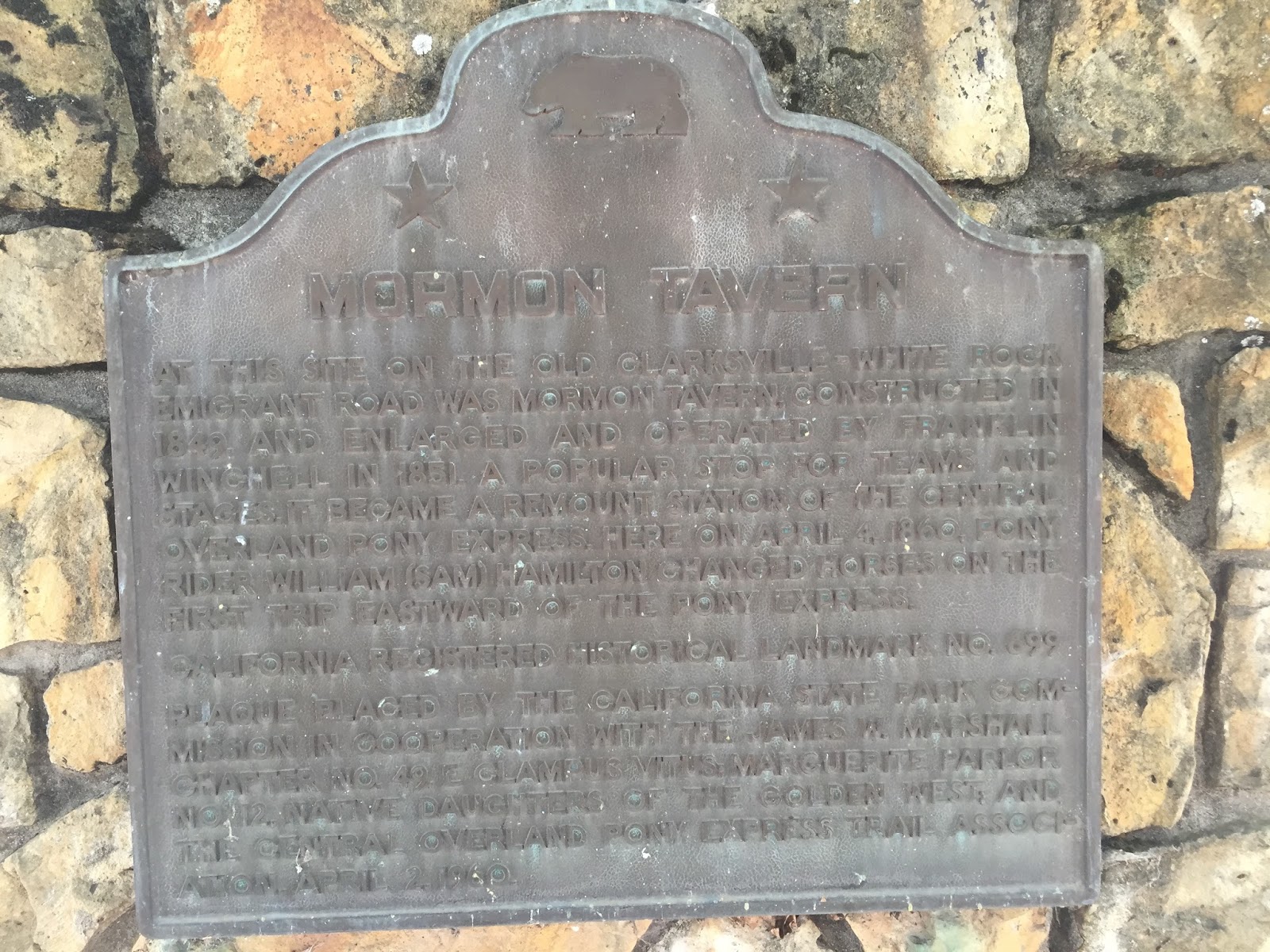
The Mormon Tavern was built in 1849 and became a remount station of the Pony Express.  You can find a neat account of the tavern here
The next three sites are all near this location.  Sadly there are no plaques or other remainders of the sites.
Negro Hill (CHL 570), Salmon Falls (CHL 571), and Condemned Bar (CHL 572) all have the same description in the state book:  These historic mining towns, and other mining camps of the gold rush era now inundated by Folsom Lake, are commemorated by the nearby Mormon Island Memorial Cemetery. Here were reburied the pioneers whose graves were flooded when the lake was formed by Folsom Dam.


Next we drove a short distance to Folsom Lake to see Mormon Island (CHL 569).
The state tells of the origins of Mormon Island:  
Early in March 1848, W. Sidney, S. Willis, and Wilford Hudson, members of the Mormon Battalion, set out from Sutter's Fort to hunt deer. Stopping on the south fork of the American River, they found gold. They told their story on returning to the fort, and soon about 150 Mormons and other miners flocked to the site, which was named Mormon Island. This was the first major gold strike in California after James W. Marshall's discovery at Coloma. The population of the town in 1853 was more than 2,500. It had four hotels, three dry-goods stores, five general merchandise stores, an express office, and many small shops. The first ball in Sacramento County was held here on December 25, 1849. A fire destroyed the town in 1856, and it was never rebuilt. Its site was inundated by Folsom Lake in 1955.
The lake was very low due to our current drought... 
but it's still a gorgeous spot.
Our final site of the day proved to be the most challenging to find.
The Pioneer Express Trail (CHL 585) was a route between the many gold towns of the area.
The plaque is located on a hillside above the Folsom Lake State Recreation Area-- we had to divide and conquer to find this one, but it was well worth the effort!
That made for 17 sites today!
On the way back to the car there may have been a race between Libi and Daddy...
Mommy just hung back and enjoyed the very dry scenery.
As a reward we stopped at a frozen yogurt shop in Folsom!

Format for hashmark fragment identifier

Click the edit icon to reveal code