Today was a full rich day. We left from our home base (my wife's parents' home in Stockton) and from their house in San Joaquin County we were able to visit sites in that county, plus Stanislaus, Mariposa, and Tuolumne Counties today--sixteen California Historical Landmarks in all. We start at the top with French Camp (CHL #668).
From the state: "Here was the terminus of the Oregon-California Trail used from about 1832 to 1845 by the French-Canadian trappers employed by the Hudson's Bay Company. Every year Michel La Framboise, among others, met fur hunters camped with their families here. In 1844 Charles M. Weber and William Gulnac promoted the first white settlers' colony on Rancho del Campo de los Franceses, which included French Camp and the site of Stockton." An interesting note: French Camp used to be known as Castoria Township. The word
castor means "beaver" in Latin, and reflects the important role of beaver furs in the early history of the region.
Also in French Camp is the
California Chicory Works (CHL #935). Chicory is the root of the endive plant. Chicory has been used as either an enhancement to coffee, or a substitute when coffee was too expensive or unavailable. "Chicory is mixed with coffee, at the average rate of about one-half pound of root to one pound of coffee. Consumers report that it adds much to the flavor of coffee," according to the
Stockton Daily Independent, Oct. 26, 1877.
Charles H. W. Brandt and Carl August Bachman were both German immigrants to the region, and began the manufacture of chicory here in 1872. Today, chicory coffee is much harder to come by, although the
Cafe du Monde in New Orleans will still sell you a cup or a can to make at home. As for the California Chicory Works, today it is
The River Mill, an event and banquet venue. You can read the full story of the California Chicory Works from
The San Joaquin Historian.
We have learned a little bit about the history of Mormon settlers in the west (Sam Brannon comes to mind), and here is another example of a Mormon settlement.
New Hope (CHL #436) would become Stanislaus City (named for the river of the same name) and it was the first agricultural colony in the San Joaquin Valley.
Note that this plaque is not where the state of California says it is. The local chapter of the historical society
E Clampus Vitus moved the plaque in 2010.
The next site on our travels is the
Temporary Detention Camps for Japanese Americans - Turlock Assembly Center (CHL #934).
Similar to the Stockton detention area we saw just a couple days ago, the Turlock center was used to temporarily detain Japanese-Americans while the US government could construct more permanent facilities during WWII. And again, similar to Stockton, the US government chose a large area with a number of indoor and outdoor enclosed areas (in this case, another fairgrounds) to house detainees. Libi is still only six-years-old (she'll turn seven in two weeks), so we are trying to explain Japanese internment in a way she can understand. We will probably wait until she is in third or fourth grade before we visit Manzanar.
Empire City (CHL #418) is another one of many (temporary) agricultural settlements we visited today. It was at one time the Stanislaus County seat, but was washed away by a flood in 1862.
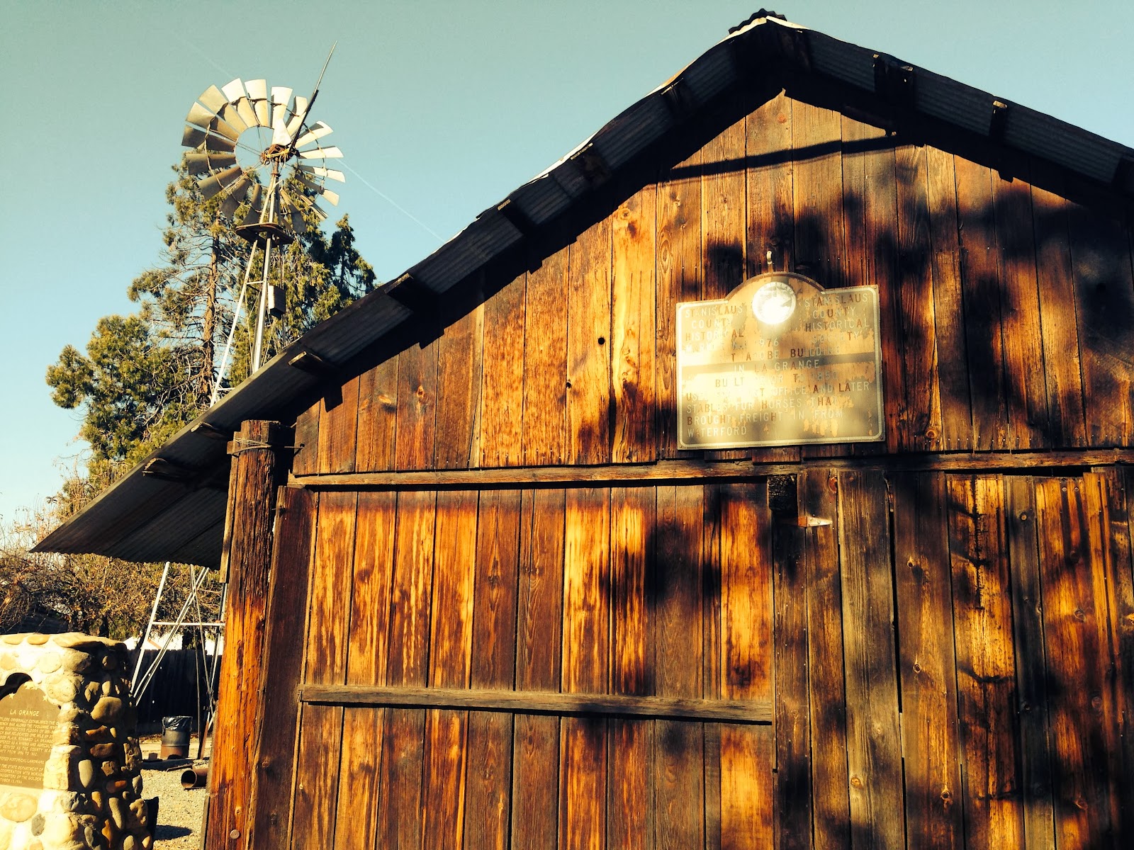
La Grange (CHL #414) served as the Stanislaus County seat from 1856 to 1862. It replaced French Bar, another town washed away by floods.
Learning about all these towns washed away by floods reminds got me thinking about the precarious balance these early settlers had to find. On the one hand, you need to be close enough to a river to irrigate your crops. The San Joaquin Valley has fertile soil, in part because of its level ground and numerous rivers fed by the mountain snows of the Sierra Nevada range. On the other hand, settling in a river valley leaves you at the mercy of flooding if rains are heavy, or if the snowpack melts too quickly.
All the interpretive buildings in La Grange were closed today (we went on a Thursday, and the museum is only open Sundays from 11 to 3), but it looks like a fun place to come back to. The Yosemite Gazette has more
information and stories about La Grange.
The geography of this part of Central California is such that we traveled from San Joaquin County, into Stanislaus County, and through a little jag of Mariposa County before entering Tuolumne County.
map courtesy of yellowmaps.com
As such, we didn't even realize it at the time, but there was an unexpected landmark we almost missed, right where Highway 132 meets Highway 49. Thanks to the eagle-eyes of my lovely wife/navigator Heather, we discovered Coulterville (CHL #332).

From the state: "George W. Coulter started a tent store here in early 1850 to supply the hundreds of miners working the rich placers of Maxwell, Boneyard, and Black Creeks. He also built the first hotel, water for it was pumped from a well by two Newfoundland dogs. Originally called Banderita from the flag flying over Coulter's store, the settlement became Maxwell Creek when the post office was established in 1853, but the name was changed the following year to honor Coulter. The family of Francisco Bruschi, who erected the first permanent building here, provided the town's leading merchants for over eighty years. Despite their crude methods, and with only wood for fuel, the nearby quartz mines operated for years and produced millions of dollars worth of gold, Andrew Goss built the first stamp mill for crushing their ore."
We were getting closer to Yosemite, so it was time for us to head up the grade to Highway 120. Our next stop was the Groveland area.
Big Oak Flat (CHL #406) was named for a giant oak tree (13 feet in diameter) that stood in the center of the town.
According to
National Geographic, the area known as Big Oak Flat comprised the towns of Groveland, Deer Flat, and Second Garrote. During the Gold Rush era, Big Oak Flat is said to have yielded nearly $28 million in gold.
Not far away from the Big Oak Flat marker is the actual town of Groveland, where we decided to stop for lunch.
Groveland (CHL #446) was formerly called First Garrote (
garrote is a Spanish word for a hanging device), so named for the hanging of a Mexican accused of stealing a horse. "Groveland" apparently had a nicer ring than "place where we hanged a guy."
If we're going to explore a historical place, we should have lunch in a historical building. Look no further than the Iron Door Saloon.
Local FOX affiliate FOX40 did a
feature on the Iron Door back in March 2013.
The food was good. The decor is one-of-a-kind.
One of the best finds in Groveland was the Yosemite Highway 120 Chamber of Commerce. There we made a new friend, Carolyn Botell. She's the Administrator for the Chamber of Commerce, is active in promoting history and tourism in the region, and an expert in this part of California. She was very helpful, giving us actual paper maps of the region (we had to go old school when our iPhone maps couldn't find a signal up in the mountains). If you're planning a trip to the Yosemite area, or if you have an interest in California and Gold Country history, like
Highway 120 Adventure on Facebook. We will definitely be back, Carolyn!
We talked about the first hanging tree in the region, the First Garrote. If they identified the first, that means they must have identified a
Second Garrote (CHL #460), right?
A portion of the hanging tree still stands today! A big thank-you to Carolyn for help finding this landmark. We have tracked down most of our sites with high technology. This one we found with a hand-drawn highway on a paper map. :)
We had to go to the Don Pedro Reservoir for our next landmark. 2013 was the driest year in recorded history, and the reservoir shows this.
Editor's note (January 30, 2013) - Part of the mining operation near the bottom of the Don Pedro Reservoir has been revealed! Sacramento News 10 just did a feature on it, and you can check it out here:
http://www.news10.net/story/news/local/2014/01/27/shawmut-mine-remnants-revealed-by-dropping-don-pedro-waters/4953535/
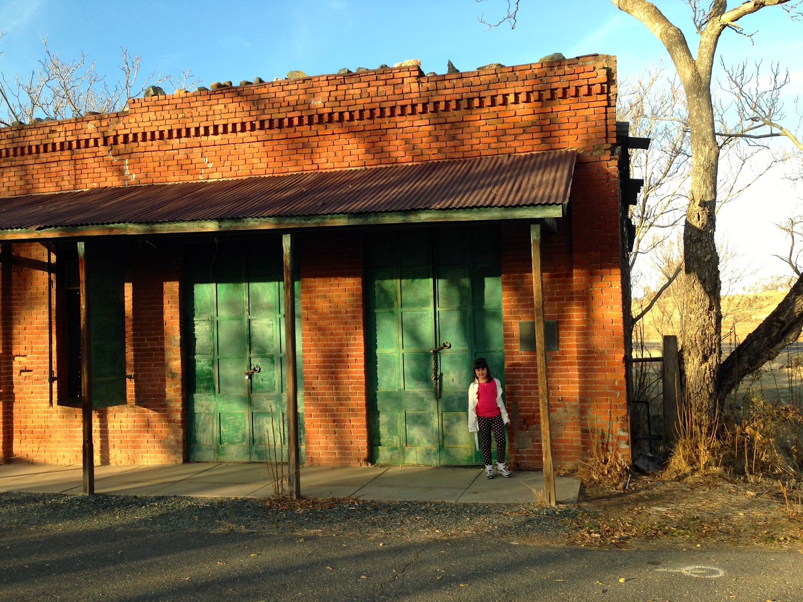
Jacksonville (CHL #419) is the next site on our list. Once a mining town with thousands of residents, the Jacksonville site is now under the waters of the reservoir.
Chinese immigration is a big part of California history, particularly the history of the Gold Rush era and beyond. That brings us to
Chinese Camp (CHL #423).
Chinese immigrants mined for gold in the hills and flats surrounding this area, and it's position at a crossroads made it a headquarters for stagecoach lines as well.
We were right next to the Wells Fargo Express Company Building and didn't realize it at the time, so we went less than a mile north of Chinese Camp to
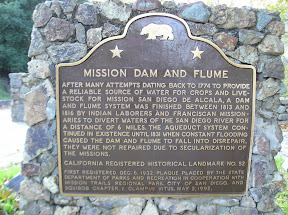
Montezuma (CHL #122).
From the state: "First record of Montezuma was June 1850 when partners Solomon Miller and Peter K. Aurand, proprietors of the 'Montezuma Tent,' were attacked and Aurand killed by a group of Mexicans during the foreign miners tax excitement of that period. Due to the lack of water, little mining occurred here until 1852 when a ditch and flume were completed bringing water for placer mining. Two types of mining were carried on, placer operations on the flats and tunnels extending under Table Mountain. The gravel produced 3-1/2 C. per pan in the mid 50s. The yield was from $5 to $10 per day. One placer nugget found in 1853 weighed 18 lbs. 8 oz. By late 1852 the population was about 800. At its zenith Montezuma City had four saloons, two hotels, Adams Express Co., post office, church, some homes, and many tents and cabins. The town was nearly destroyed by an incendiary fire which started in Clarks Hotel on June 29, 1866."
OK, now back into Chinese Camp, where we finally discovered the
Wells Fargo Express Company Building (CHL #140). It was a general merchandise store and was home to the Adams Express Company, predecessor of Wells Fargo & Company.
There's no official plaque, but there is this plaque from
E Clampus Vitus to honor 19th century stage driver Eddie Webb.
The sun is setting on Gold Country, so we have to hurry and get our last two landmarks of the day! Next is
The Willms Ranch (CHL #415). John R. Willms arrived in California in 1849.
The ranch has been in the family ever since. The home is currently under renovation (cool before and after photos
HERE).
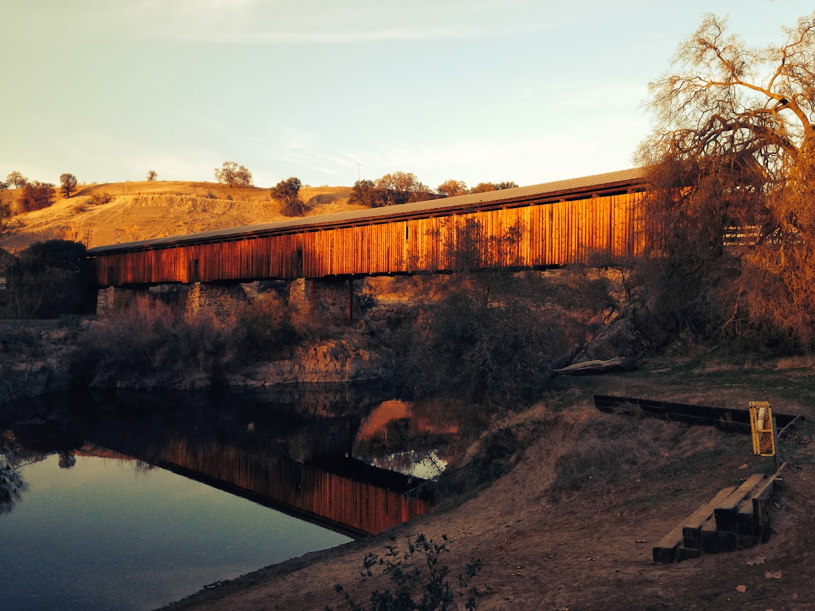
Our last stop of the day is Knight's Ferry (CHL #347).
We were tired and the sun was setting, so we almost just took Libi's photo saying that Knight's Ferry is a mile away, but we decided to go check it out. It was worth the effort. Knight's Ferry served as a mining center, trading post, and flour mill. It is also home to the longest covered bridge west of the Mississippi River.
The bridge is a candidate for status as a National Historic Landmark. This description is straight from the
NHL application: "The Knight’s Ferry Bridge spans the Stanislaus River in a picturesque natural and historical setting at the interface of the rolling Sierra Nevada foothills and the fertile farmlands of California’s Central Valley. It is an arid landscape of rolling hills and prairie, sparsely covered with groves of oak trees and sagebrush. The Stanislaus River, one of ten rivers that drain the Sierra Nevada, travels 96 miles in a westerly direction from the foothills north of Sonora to the confluence of the San Joaquin River near Ripon. At Knight’s Ferry, the river exits the confines of a narrow canyon and begins a slower, meandering course through the valley. This proved to be an ideal site for a ferry—and later, a bridge—as the topography here allowed travelers to be safely conveyed across the river. This crossing was essential to the Sonora Road, one of the principal overland routes used by miners traveling between the Central Valley and the southern mines during the California gold rush. The volume of traffic generated by miners traveling the Sonora Road enabled Knight’s Ferry to quickly develop into a thriving industrial village, which also served as the seat of Stanislaus County from 1862 to 1871."

Knight's
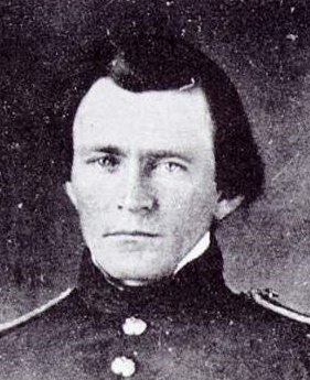
Ferry, of course, began as a ferry boat across the river, but plans would soon be made to simply build a bridge across the river. Two of the owners of Knight's Ferry in the 1850s were brothers John and Lewis Dent. John and Lewis had a sister (Julia) back in Missouri who had just gotten married to a family friend named Hiram. Hiram and the oldest Dent brother, Frederick, were roommates at West Point.
photo of young Hiram, courtesy of argenweb.net
Hiram had a good job as an Army captain, but resigned his commission in 1854 to pursue life in the private sector. He left Julia (pregnant with their second child) with his in-laws, and went out west to Stanislaus County for a summer to pick up some work with his brothers-in-law, John and Lewis. During that time, it is rumored that he drew up some plans for the bridge that now spans the Stanislaus River.
He left at summer's end, and would continue to seek his fortune (and fail miserably) for the next seven years. The Army, after all, was where Hiram belonged. You may know Hiram Ulysses Grant as the name he used to enter West Point, Ulysses S. Grant. According to Dr. Joan Waugh (she wrote the 2009 biography,
U. S. Grant: American Hero, American Myth, plus I also was enrolled in two of her classes at UCLA), Grant altered his name because he didn't want to be teased for the initials (H.U.G.) given to him at birth. Considering he was the general who saved the Union in the Civil War, we'll forgive him if he had to jump around from job to job for seven years, including a brief stint in the summer of 1854 right here in Stanislaus County.
image from guns.com
Full of history, and some corners that we have yet to explore, we're definitely putting Knight's Ferry on our list of "places to return to," and . . . great news! We have visited every historical site in Stanislaus County, which makes it our first COMPLETED county. Hurray! Only 57 counties to go!


Dear Ron, Heather & Libi...
ReplyDeleteDelightful blog post!
Yes, Hiram was brother-in-law to the Dent's. We located their etched names at Cold Springs Oklahoma in 2008 as we rehiked the Mormon Battalion's route. John was a cavalry captain under Colonel Sterling Price (Missouri mounted regiment) and Lewis was a civilian employee under his buddy, Col Cloud - paymaster for the Army of the West. The etched names had not been recognized previously. If you'd like more information, contact me at budhenson - at - aol.com.