What an education we received today! I knew citrus was important along Highway 126. I knew citrus was important in the development of Orange County. However, I had no idea that the California citrus industry began right here in Riverside County. We began our journey in Corona, California: the Circle City. Originally they were just going to call it South Riverside, but the city was laid out by civil engineer H. Clay Kellogg with the main street (Grand Blvd) forming a circle around the city center with a one-mile diameter.
map courtesy of Apple Maps
We went in search of the Corona Founders Monument (CHL #738), and it was an easy find, right in the center of City Park.
City Park in Corona also features an Australian bunya-bunya tree. It's a conifer whose seed pods (pine cones) can weigh up to 15 pounds!
No wonder they had the warning sign! I wouldn't want something as heavy as a bowling ball falling 30 feet onto my head. Perhaps I shouldn't have even stopped long enough to take this photo of the side of the tree, then.
Alright, back in the car, away from city center and out into the hinterlands to seek out the
Serrano Boulder (CHL #185). Leandro Serrano, the son of one of the original members of Father Junipero Serra's expedition and he is credited as being the first non-Indian permanent resident of what would become Riverside County. In 1818, Serrano settled here in the Temescal Canyon--a place teeming with bears, mountain lions, and other wildlife. He spent the next 30 years taming this land, raising cattle and other livestock, farming, and raising a family. Behind this heavy brush is the boulder that marks the site of Serrano's first adobe home (no official marker exists).

Serrano served as the mayordomo of the San Antonio de Pala Asistencia for Mission San Luis Rey, and later the mayordomo of the Mission San Juan Capistrano, so he was kind of a big deal. Under the terms of the Treaty of Guadalupe-Hidalgo that ended the Mexican-American War, all landowners could keep the property they had rightfully acquired before the land came under the control of the United States. By decree of the Land Act of 1851, all Californios were required to prove that their land claims were legitimate based on a title given them either by the government of Spain (until 1821) or Mexico (1821-1846). Serrano died in early 1852, so it was up to his widow, Josefa Montalva de Serrano, to file the claim on behalf of the family. Unfortunately for her and the family, Serrano never got a deed. He simply was given permission by the Catholic Church to settle Rancho Temescal. When Mexico declared independence in 1821, it never required Serrano to show proof of ownership, and unfortunately for Serrano, he didn't take the steps (according to records the process actually would have been pretty simple under Mexican law) to apply for a lawful deed to the land. Oops. Josefa was denied her claim in 1855. She won an appeal in 1859 in US District Court, but the federal government appealed, and the case went all the way to US Supreme Court. Here is an excerpt from the ruling in
Serrano v. United States (1866):
from Cases Argued and Adjudged by the US Supreme Court: 1866. Digitized by Google eBooks.
Long story short: the Supreme Court denied Serrano's widow her claim to the land. After the Supreme Court ruling, Josefa applied for a homestead, and was granted the 160 acres of land surrounding their home. Had she won the case, she and Serrano's descendants would have won claim to over 30,500 acres.
I'm a social studies teacher, so I have a pretty decent understanding of geography. However, it hasn't been until this project that I really realize how the lay of the land influences where people live, where people travel, how they trade, and how they interact.
screenshot from Google Maps; arrows created using Skitch
Old Temescal Road (CHL #638) is an important part of that geography. The Temescal Valley had been inhabited by the Luiseño and Gabrieleño Indians for hundreds of years. Those Native Americans established trails in and out of the valley. Later, the Spanish, Mexicans, and finally citizens of the United States traveled the Old Temescal Road as they went into the Los Angeles basin from San Diego or from Arizona and points east.
This plaque is the first of its kind we have seen on our travels--a granite marker! I was just talking to Heather about how frustrating it is that so many bronze markers have been stolen. We have seen dozens of empty plinths where plaques once stood. I told my wife, "They should these markers out of stone rather than metal to make it so if you try to remove it, you end up destroying it." We'll have to come back in a couple years to see if the plaque survives.
The next landmark is
Carved Rock (CHL #187). It's back there in those hills behind the private property sign. According to
landmarkquest.com, there is no plaque, and the site is "very hard to find." YouTube user davidsquall351 has a
video of him driving out on a dirt road to Carved Rock. I posted a comment to his video asking him if he was able to access the site through public roads, because if there are, we couldn't find them. He messaged me back within just a couple hours, and there
is a way. Honey, I think we're going back to Corona. :) David, per your request, I won't post the directions you gave me, but I so appreciate your sharing them. You're exactly right, and it's unfortunate that so many of our other state's treasures have been vandalized.
So this is as far we got . . . for now.
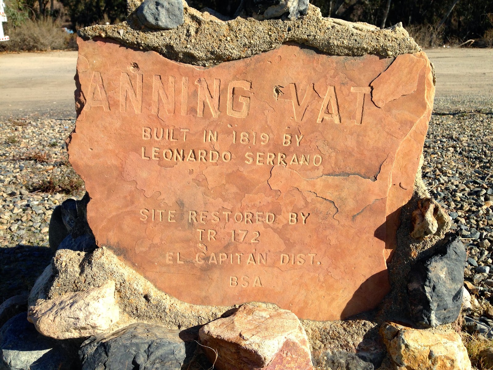
We learned how important the Serrano family was to the history of this part of California. Here is the
Site of the Third Serrano Adobe (CHL #224) and the
Serrano Tanning Vats (CHL #186).
The Spanish/Mexican inhabitants of California had numerous occasions to interact with local Native Americans populations. Here is an example of Native American culture that we were able to get much closer to (unlike Carved Rock). This one is called
Painted Rock (CHL #190). We had trouble finding this one too, at first. It's just off a road that leads up to one of Riverside County's largest landfills. We just couldn't spot it, so we went to the other side of the dry riverbed to spot it, and sure enough, there it was! Here is Heather getting a shot from across the wash.
We then went back across and started tromping a bit. The terrain is tough, so this is as close as the three of us got.
Being the adventurous type, I decided to cross
back over to the other side of the riverbed, and tromp through the rocks and brush. There's the front of Painted Rock. No plaque, just a metal barrier to kind-of protect the site.
Moving on to our next site, and here was
another tough find! The state of California gives a specific address for the
Butterfield Stage Station (CHL #188). I won't go into the full history of the Butterfield Stage Line (because I already have,
here). Here is the actual physical address on Temescal Canyon Road where the plaque is supposed to be.
Then we did a little research that said the plaque had been moved to this neighborhood here.
As it turns out, we did go to the correct place where the station used to be, but the plaque got moved just a few years ago when they put in some new home development in this area. We are giving ourselves credit for the find, but when we return to Riverside County, we are going specifically to these GPS coordinates:
N 33° 48.976 W 117° 30.511.
OK, next on our journey is a site that was very well labeled, and kind of awesome! It's the
Parent Washington Navel Orange Tree (CHL #20). This is one of two trees (the other one died in the 1920s), brought here from Brazil in 1873, that is the source of all California navel oranges.

Because navel orange trees have non-reproducing fruit, if you want to plant new navel orange trees, you have to take clippings from existing trees. That basically means that
every navel orange you eat from California is genetically the same as the fruit from this tree right here. Crazy!
This was also a great opportunity to teach Libi about smudge pots. They were first used in California after a disastrous citrus freeze in the winter of 1913. Today you can see them in orange groves all over the state.
Our next landmark took us out to a golf course where we encountered the marker for the
De Anza Crossing of the Santa Ana River, 1775 and 1776 (CHL #787).
Other Spaniards had reached the Pacific coast by sea, but Juan Bautista De Anza was the first to lead an expedition overland from Sonora. He and his party crossed the Santa Ana River at this location, and continued on north to eventually scout the location of the village of Yerba Buena. A presidio would be built to defend the village and to protect the Misión San Francisco de Asís. We know this village today by another name: San Francisco.
If you go looking for the site, it's at the Jurupa Hills Country Club, in between the clubhouse and the first tee.
Next stop on our Riverside County journey was the
Cornelius and Mercedes Jensen Ranch (CHL #943) in Rubidoux. The Jensen family is a great example of so many early California families--blending Northern European and Spanish/Mexican cultures. Cornelius Jensen was a Danish sea captain who made his fortune in shipping cargo around Cape Horn to the Pacific Coast. He later settled in California and married the daughter of a prominent Californio family, Mercedes Alvarado.
The grounds have been beautifully maintained, and are still used today for field trips and special events.
The setting sun made for some great photos of old farm equipment.
The house itself is the oldest non-adobe structure in the Inland Empire.
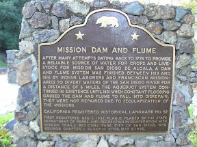
Next up is the Site of Rubidoux Grist Mill (CHL #303). From the state: "One of the first grist mills in this part of Southern California was built by Louis Rubidoux on the Rancho Jurupa in 1846-47. Then the only mill there of its kind, it supplied a great need. Louis Rubidoux, a pioneer builder, was one of the first permanent American citizens in the valley."
We enjoyed the site because it is literally in a neighborhood in between two houses!
Our last site (before grand finale) is the
Site of Louis Rubidoux House (CHL #102). Key here is this
was the site of the house, but now it's just a strip mall.
The funny thing is we took this photo not having looked at the entry for this site on
landmarkquest.com (the site maintained by David Schmitt which has been extremely helpful to our travels). Here is the photo he took of the Rubidoux site, below. Same building, just different signage.
photo by David Schmitt
It is now time for the big finish to our Riverside County trip: The Mission Inn (CHL #761). The Mission Inn is a storied building that's been around since the turn of hte 20th century. Remember that second navel orange tree that died in the 1920s? It was moved from the location you saw earlier in this blog entry to the Mission Inn. Which famous American helped transplant that orange tree? Look carefully at the photo below at the man with the shovel.
Need a closer look?
Why yes! That is none other than President Theodore Roosevelt (don't call him "Teddy;" he hated when people would call him "Teddy"). He stayed at the Mission Inn in 1903, and was the first President to visit while in office (Editor's note: The Mission Inn website claims that the original orange tree is still at the resort. Other sources say the tree died. Guess I still have to do a little more research on this one). A total of 11 Presidents have stayed here, and Richard and Pat Nixon even honeymooned here.
This symbol below is prominent throughout Riverside. It's the raincross symbol. This one is in the Mission Inn museum.
According to the
Flags of the World website: "The unique City Raincross Symbol is derived from combining a replica of the mass bell used by Father Junipero Serra, missionary priest and founder of the California Missions' chain, and the cross to which the Navajos and Central American Indians prayed for rain. The "Raincross" is used extensively throughout Riverside in its architecture and ornamentation and is on the City flag. The raincross symbol was designed for the Mission Inn and given to the city by the hotel's owner, Cpt Christopher Columbus Miller, and has been identified with Riverside since 1907."
The Mission Inn is a working hotel and resort, and makes a big deal out of decorating for the holidays. Heather stayed here a long time ago, and recalled fondly how much they get all decked out for Christmas.
While waiting for the light display to begin, we had a great dinner at an Italian restaurant in the Mission Inn complex: Bella Tratoria.
Once the sun went down, the lights came on and the crowds converged upon the Mission Inn. There is a path you can follow through the resort full of holiday displays. My photos won't do it justice, but here is Libi at one of them.
It was opening weekend of the big light display, and so the crowds were big. If you go during the holiday season, get there early in the day (that was the smart thing we did) and prepare for LOTS of people!
In spite of the heavy crowds, it was still pretty spectacular (I think I grumbled a little bit as we pushed our way through the throngs of people). Riverside County was pretty cool, and I'm actually looking forward to bringing the family back for more! In our next blog entry, we are headed to Pasadena. See you then!