Saturday, October 24, 2015

Exploring the Kern County Desert - 10/24/2015

Due to school starting we had to take a little break from our CHL adventures, but now we are back on track!  We decided to do a day trip to Kern County to see Willow Springs (CHL 130)
This spring was visited by several parties traveling through California-- Padre Garces, the Jayhawk Party, and operated as a stage station on the Inyo Lines. 
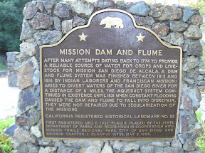
Our next landmark for the day was in front of a deserted restaurant building, the 20-Mule Team Borax Terminus (CHL 652).
The borax wagons traveled from here to Death Valley from 1884-1889.  
We next found Desert Spring (CHL 476).  This is one of the most important sites in the desert--a water spring!
According to the state:  This spring was on an old Indian horse thief trail and later (1834) Joe Walker Trail. The famished Manly-Jayhawk Death Valley parties (1849-50) were revived here after coming from Indian Wells through Last Chance Canyon. This was also a station on the Nadeau Borax Freight Road.
You can actually still see the remnants of a spring here-- which is pretty cool!
Our path next brought us to Freeman Junction (CHL 766).
The plaque reads:
In 1834 explorer Joseph R. Walker passed this junction of Indian trails after discovering nearby Walker Pass. Death Valley 49er parties here diverged west and south after their escape from Death Valley enroute to the California gold fields. Later this became a junction point where the bandit Tiburcio Vasquez preyed on stages and freighters traveling between the Kern River mines and Los Angeles and the mines of Bodie and the Panamints.
Now this plaque just seems to be target practice for local teens.
A short drive into the hills brought us to Walker's Pass (CHL 99).
On the plaque:  Discovered by Joseph R. Walker, American trail-blazer, who left the San Joaquin Valley through this pass in 1834. This area was traversed by topographer Edward M. Kern, after whom the Kern River was named, while accompanying the Frémont expedition of 1845. After 1860 it became a mining freight route to Owens Valley.
Happily there is an additional plaque here for Joseph Walker!  He was a true mountain man who spent most of his life exploring, charting and guiding people through California.  Interesting to note-- this pass is essentially the same as it was when he discovered it.  I think the only difference is that it is now a paved road.
Our next stop for the day was Indian Wells (CHL 457).
From the state:  After five days' travel from the Argus Range, the Manly-Jayhawker parties of 1849 found their first water at this Indian waterhole on the Joseph R. Walker Trail of 1843. During the 1860s, this was the site of a stage and freight station for traffic between Los Angeles and the Coso and Cerro Gordo Mines.
Indian water hole on Joseph R. Walker trail of 1834 where Manly-Jayhawker parties of 1849 found their first water after five days of travel from Argus Range. During 1860's was site of stage and freight station from Los Angeles to Coso and Cerro Gordo mines.
Site of the Town of Garlock (CHL 671) was our next stop as we raced the sun to hit all of our spots before night-fall.  
The guidebook says:  In 1896, Eugene Garlock constructed a stamp mill near this spot to crush gold ore from the Yellow Aster Mine on Rand Mountain. Known originally as Cow Wells by prospectors and freighters during the 1880s and early 1890s, the town of Garlock continued to thrive until 1898, when water was piped from here to Randsburg and the Kramer-Randsburg rail line was completed.
In a small community in the middle of nowhere, we found the Rand Mining District (CHL 938).

The guidebook says:  The Yellow Aster, or Rand mine was discovered in April 1895 by Singleton, Burcham, and Mooers. The town of Randsburg quickly developed, followed by the supply town of Johannesburg in 1896. Both names were adopted from the profusion of minerals resembling those of the ranch mining district in South Africa. In 1907, Churchill discovered tungsten in Atolia, used in steel alloy during World War I. In June 1919, Williams and Nosser discovered the famous California Rand Silver Mine at Red Mountain.
For our final site we left Kern County and headed to San Bernadino County to hit Trona and the Searles Lake Borax Discovery (CHL 774).
This was our first visit to Trona-- which was very short due to the setting sun.  The only thing we noticed about the town was a distinct smell. 
The guidebook says the site is significant for the following reasons:  Borax was discovered on the nearby surface of Searles Lake by John Searles in 1862. With his brother Dennis, he formed the San Bernardino Borax Mining Company in 1873 and operated it until 1897. The chemicals in Searles Lake, which included borax, potash, soda ash, salt cake, and lithium, were deposited here by the runoff waters from melting ice age glaciers. John Searles' discovery has proved to be the world's richest chemical storehouse, containing half the natural elements known to man.
And there ends another day of adventuring to track down all of the California historic landmarks. 

Saturday, September 26, 2015

Adobes, Grapevines, and Arrowheads in San Bernardino County - 9/26/15

Since we didn't visit any sites in August-- gasp!-- we decided that we needed to get a move on.  Therefore, after a lovely night at the Disneyland Halloween Party we took off for San Bernardino sites.
Our first site was the Yorba-Slaughter Adobe (CHL 191).
This adobe was built in the early 1850s by Raimundo Yorba and was purchased by Fenton Mercer Slaughter in 1868.
The adobe was sometimes called "Buena Vista" and the road below it was well traveled, since it was party of the road from Fort Yuma to Los Angles.  This was also an optional stop on the Butterfield Overland Stage Route.  Fenton M. Slaughter was an interesting fellow who gained wealth sheep ranching and eventually served in the California State Assembly.
The sign said that it was open for touring on Saturdays, but the gate was firmly locked when we visited-- there was a great deal of construction on the adjacent road, so perhaps it is closed for now.
A short drive away (and nowhere near where the address says it should be) we came to the Site of the Rancho Chino Adobe of Isaac Williams (CHL 942).
From the state:  "Near this site, Isaac Williams in 1841 built a large adobe home, located on the 22,000-acre Rancho Chino which he acquired from his father-in-law Antonio Lugo. The 'Battle of Chino' occurred at the adobe on September 26-27, 1846, during which 24 Americans were captured by a group of about 50 Californios. Located on the Southern Immigrant Trail to California, the adobe later became an inn and stage stop famous for its hospitality."
I did a little more research on the Battle of Chino, since it was only briefly mentioned by the state-- here is what I found:  This "battle" of the Mexican-American War was fought September 26-27, 1846 and involved about 50 Californios coming to arrest 24 Americans who were barricaded inside the adobe.  On the morning of September 27th gunfire was exchanged and one Californio was killed.  In order to get the Americans to surrender, the Californios threatened to set the adobe on fire.  It worked and the Americans were arrested and held in prison briefly before they were released.
Moving from Chino to San Bernardino we came to the Site of Mormon Stockade (CHL 44).
It is said that the first house in San Bernardino was built near this spot in 1839.
However, it is much more famous for this being the site of the Mormon Stockade.
I found on this site a really great description of what the stockade looked like (which you can read below).  I can only imagine living in such a restricted place with 1000 people!
"In June of 1851, the Mormon newcomers in San Bernardino were alerted of Indian skirmishes and raiding dangers in the area. In the center of their new mile-square town of San Bernardino, the leaders set aside eight acres and fenced in a parallelogram. 300 feet wide by 720 feet. Twelve foot high walls protected three of the sides. The fourth side was a series of log buildings jammed close together. All exterior walls were loop-holed and the gateways were indented to allow for crossfire. 

Ranger Horace Bell, In his book Reminisces of a Ranger, described the structure as "a stockade about a quarter of a mile square with two great gates leading into it. Inside they placed their dwellings, shops and stores. Every night the gates were barred and a sentry kept vigilant watch from the walls against surprise." The Mormons stayed in the stockade for approximately nine months, the anticipated war with the Mojave Indians never occurred. It was in October of 1857, when Brigham Young called the "saints" to "Zion."

On December 27, 1958, when United States Colonel William Hoffman's "Mojave Expedition" camped near the original Cajon, they learned that approximately 1,000 had stayed in the area of San Bernardino." 
Next up was one of the coolest sites we've been to in a while... the Arrowhead (CHL 977).
This supposedly natural phenomenon of an arrowhead on the hillside has been a landmark in this area for centuries.
Native Americans looked to it to find the mineral springs below.
The arrow "consists of light quartz, supporting a growth of short white sage" according to the state.
We took this chance to take a family photo with the famous arrowhead!
We continued north up to Glen Helen Regional Park to find the Sycamore Grove (CHL 573).
The Mormons who stockaded themselves in our site earlier today camped here in June of 1851-- it was their first campsite.  Captain Jefferson Hunt (a captain of the Mormon battalion and later a California State Assemblyman), Amasa Lyman (one of the first right-hand men to Joseph Smith), Charles C. Rich (an apostle of the LDS church), David Seely (a Mormon pioneer), and Andrew Lytle (was the captain of the wagon train that brought them out to California) were among those who camped here.  You can read a fascinating account of this group here.  

Next up was one of the strangest landmarks we have ever visited-- the United States Rabbit Experimental Station (CHL 950).
This is the first and only experimental station in the country that is devoted to rabbit research.
  Over the years of research here they increased the amount of litters a female have each year and increased the average weight of the rabbits while cutting food costs.  You can watch a video about the facility here or read an interesting news article here.
Our next site was a two-fer-- and boy do we love hitting two sites at once.  The first was the site of the Tapia Adobe (CHL 360).
Near this site in 1839 Tiburcio Tapia, a soldier, merchant and alcalde in Los Angeles built an adobe on land granted to him by Governor Juan Alvarado.
The adobe was abandoned in 1858 and completely disintegrated-- so sadly there is no site left.
Tiburcio also established the Cucamonga Rancho Winery (CHL 490)-- which is advertised to be the state's oldest winery.
It seems that we have visited the state's oldest winery in a few different counties-- so just take that with a grain of salt... It is an old winery and one of the first in the great state of California!
There is a sad looking vine on the property-- which looks like it has been here since 1839 :(
It was fun to travel along Route 66 for a bit!
Our final site for the day--- and one of the most interesting we've ever seen is the Madonna of the Trail (CHL 1028).
There are actually 12 of these statues across the country-- each sculpted by August Leimbach and financed by the National Society of the Daughters of the American Revolution.
Two of the sides are identical on each of the pedestals-- the one above and the one below.
The other two sides are specific to the location of the statue.
The statues are meant to commemorate the westward movement of the American people and the role of pioneer women during that challenging time.  
The statue we saw in Upland represents four historic trails:  the Mojave Trail, the de Anza Trail, the Emigrant Train and the Canyon Road.
The rifle on this statue was modeled after Daniel Boone's-- which was very difficult to see the details.
The sculptor also hid a snake in the grass at the base of the statue-- we were able to find it, can you?
After we complete California we want to see all of the other statues.
You can see a list of the cities where all of the statues are here.
It was so fun to get back into the swing of things with our California Adventures.

Format for hashmark fragment identifier

Click the edit icon to reveal code