We are working on having Libi take over the blog-- today was our first attempt to ease her into it. All of the comments you see in pink are her words, which are typed by her (this takes forever when you are 7 years old)!
Our goal today was to hit 23 sites.
Our first site today was Stone Corral (CHL 263).
This used to be a hotel and barns along with the corrals that were used a stopping places on the way to the Stockton mines. There is nothing left today except a church that took the same name.
There is a church named Stone Corral Church.
Our next stop was the town of
Jenny Lind (CHL 266) who Ron discovered was named after a Swedish opera singer who was very famous in Northern California in the early 1800's.
Jenny Lind is a cute town.
The town, which now is pretty small, was once a placer mining community in 1849. Interestingly when the town census was done in 1864 half of the 400 residents were Chinese.
Milton (CHL 262) was our next stop. It was a quaint little "town" in the middle of nowhere.
There are old houses.
Milton came to be because of the Southern Pacific Railroad which came through the town in 1871. This was the first town in Calaveras County to have a railroad station.
We turned back toward civilization to
Valley Springs (CHL 251). This is another site defined by the railroad-- in 1885 a narrow gauge railroad ended here which was eventually turned into a standard-gauge line.
We went to a store that had gold.
As Libi pointed out, we went to a curiosity shop inside the old train station where the nicest man told us all about the history of mining in the nearby areas. He showed us some of the equipment that was used, samples from the mines, and old photographs he has collected over time. If you stop into town, be sure to say hello!
There's a court house.
We searched
Double Springs (CHL 264) for the courthouse Libi mentioned-- it is made with wood from China and it is supposedly still standing, but we couldn't locate it anywhere! The town was once the county seat, hence it's claim to fame.
Next we were excited to find the
Pioneer Cemetery (CHL 271)-- even more exciting was that it was open for visitation! We have discovered lots of cool old cemeteries are locked to prevent vandalism, but this one was only behind a cattle gate which was unlocked.
There was a cross on a grave.
This cemetery was located across from the town of North Branch and founded around 1851.
In 1936 only three of the graves had markers on them-- it seems that many of them have been replaced.
Next we drove on to the town of
San Andreas (CHL 252)-- which was darling!
The town was originally settled by Mexicans in 1848 and was a mining town right from the start. San Andreas has many other claims to fame including being the location of the trail for Black Bart and a rendezvous point for robber Joaquin Murieta.
Andrew in Spanish is Andreas.
Calaveritas (CHL 255) was another mining town settled by Mexican pioneers. It was also a hang-out for Joaquin Murieta. The town was destroyed by fire in 1858.
In Spanish it means little skeletons.
Fourth Crossing (CHL 258) is yet another mining town which was also a stop on the stage route. It was originally called Foremans and it was primarily a placer ore mining spot for over 50 years.
There were stones.
Our next site is one we will absolutely be returning to when we have more time!
California Caverns at Cave City (CHL 956) are one of the earliest recorded caves in the Mother Lode. There were organized tours of these extensive caves and caverns as early at 1854!
There is a cave you can go in.
El Dorado (CHL 282) became a town in 1872. It was named after a local saw mill.
There is a bell on the marker.
The bell was used in the local school house from 1885-1953, and it now rests on top of the private plaque.
Several mountain roads later we came to
Rail Road Flat (CHL 286). Surprise, surprise this was a former mining town that got its name after the mule-drawn ore cars used here.
There are bison and llamas.
The farm across the way raises bison and llamas-- as the man who worked at the California Caverns told us when he was trying to help us find some other CHLs.
West Point (CHL 268) was named by famed mountain man Kit Carson during his search for a pass over the Sierras. Bret Harte also lived here for a short time.
There is a sign that says '' Poach go to JAIL! ''
Our city girl thought this sign was quite odd. We had to explain to her what it meant-- now she is studying laws in school and she claims this is her favorite law because: "It is rude to kill animals in the wild!"
This next site gets the award for the creepiest CHL in all of Gold Country-- still the creepiest site we've seen was the Folk Art in LA. Sandy Gulch (CHL 253) was a trading center for miners in the mid 1800's. Gold was found here, quartz mining also occurred here, and one of the Hangman's Trees for the state stood near the center of town.
There were creepy headless horses!
Now all that is left is this crazy display of a wagon with headless horses. Very strange!
Glencoe also called Mosquito Gulch (CHL 280) was a short drive down the road. The town was a quartz mine that was begun by Mexicans in the early 1850's. According to the state none of the original buildings remain.
There is no marker.
Jesus Maria (CHL 284) was a mining town named after the man who raised vegetables and melons for the miners. The town was settled by a diverse population including Mexican, French, Chilean, and Italian settlers.
There were dogs close by us.
The next few sites were all located in a darling little town called Mokelumne Hill.
Libi found one of the markers!
The first we came upon after parking the car was the
Courthouse of Calaveras County, 1852-1866, and Leger Hotel (CHL 663). This served as the county seat, until it was moved to San Andreas. George Leger bought the courthouse after that and included it as part of his hotel. The hotel caught fire in 1874, but it was restored in 1879 and is still a hotel today. Coincidentally they have very lovely restrooms and a cool little lobby. They were very happy to let us look around and explore! It would be fun to stay in a place that has been a hotel since the Gold Rush days!
Next was the actual plaque for
Mokelumne Hill (CHL 269). First settled by fur trappers and later a major placer mining town, Mokelumne Hill has had a long history. Gold was so plentiful here that they had to limit claims to sixteen feet. Even so many of the claims produced over $20,000 worth of gold!
It has been destroyed by fires in 1854, 1864, and 1874-- the moral of this story is don't visit in a year that ends in a 4!
A short walk down the hill brought us to the
I.O.O.F Hall, Mokelumne Hill (CHL 256). This is supposedly the first three story building built away from the coast in California. The first two stories were constructed first, then the third story was added later for the Odd Fellows lodge.
On our way back to the car we found another private plaque for the Hill.
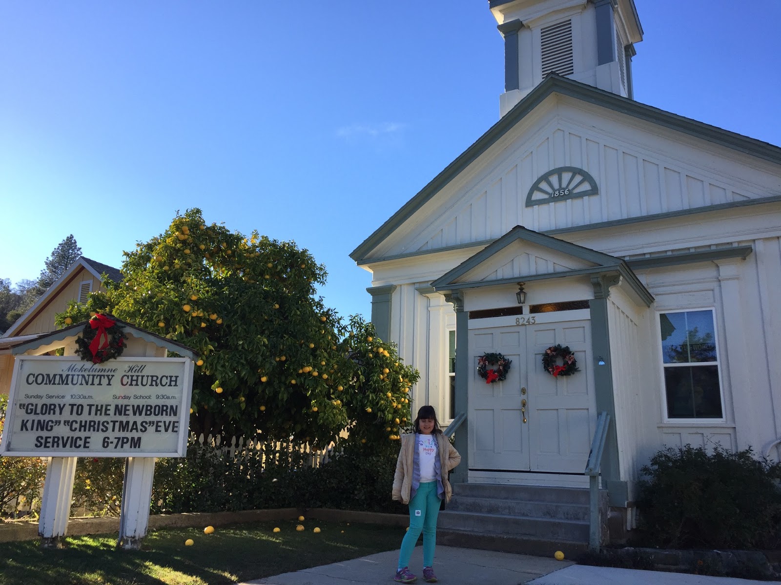
On our way out of town we came to the final site in Mokelumne, the
Congregational Church (CHL 261).
Built in 1856 this is the oldest Congregational Church building in all of California. It is still in use today!
Chili Gulch (CHL 265) was the site of the Chilean War in 1849. Due to unrest between the Anglo-European miners and the Chilean miners a document was written up to oust the Chileans from their claims-- this caused several skirmishes and several deaths.
On a happier note, the largest known quartz crystals were recovered from a mine here.
It sounded yummy!
Paloma (CHL 295) was a gold and quartz mining town beginning in 1849.
In 1851 California Senator William M. Gwin bought property here and opened a mine. In 1908, after mining millions of dollars in gold, the mines were closed. Gwin was quite a character-- CA's first U.S. Senator with John C. Freemont, he was a southern sympathizer who plotted with Napolean III to move slave owners to Sonora, and he even engaged in a dual where only a donkey was killed!
The post office is for rent.
Our final stop was a bit tricky so we didn't find the plaque!
Camanche (CHL 254) was formerly called Limerick. It was a mining town, that had a large Chinatown which was destroyed by fire in 1873. It is now the Camanche Reservoir and it was full of tourists who were camping for New Year's Eve. We waited in line to enter the park for 20 minutes, but decided that this sign would have to do!