


We visited my folks for President's Day weekend so we could get some more sites ticked off the list. Today we hit several 780 sites (Transcontinental Railroad sites)-- the first of which being CHL 780-1 First Transcontinental Railroad- Roseville.

The plaque reads: Central Pacific graders arrived at Junction on November 23, 1863, and when track reached there on April 25, 1864, trains began making the 18-mile run to and from Sacramento daily. The new line crossed a line reaching northward from Folsom that the California Central had begun in 1858 and abandoned in 1868. Junction, now called Roseville, became a major railroad distribution center.

Roseville, which was originally called Junction, came to be specifically due to the railroads. You can read more about the history of Roseville here.

We followed the trains to CHL 780-2 First Transcontinental Railroad- Rocklin.

This was a major hub for the railroad-- with a roundhouse that sadly fell into disrepair and has since been demolished.

We took a quick break from transcontinental railroad sites to visit Griffith Quarry (CHL 885).

The plaque reads: Established in the fall of 1864 by Mr. Griffith Griffith, a native of Wales, the quarry located near this site supplied high-quality granite for a number of the important buildings in San Francisco and Sacramento, including portions of the state capitol. This was also the site of the state's first successful commercial granite polishing mill, erected in 1874.

The cool things for us Southern Californians is that Grifith Griffith's is the same man who gave his name to Griffith Park.

We didn't know much about the man, so we looked him up and found him to be fascinating, an immigrant who made money mining who turned philanthropist and then shot his wife in a drunken rage.

Well, on to happier things... next we returned to another railroad site, the First Transcontinental Railroad-- Newcastle (CHL 780-3).

The plaque reads: Regular freight and passenger trains began operating over the first 31 miles of Central Pacific's line to Newcastle on June 10, 1864, when political opposition and lack of money stopped further construction during that mild winter. Construction was resumed in April 1865. At this point, stagecoaches transferred passengers from the Dutch Flat Wagon Road.

The fun thing about this site is that there was an antique store right next to the plaque. We spent some time enjoying the treasurers which included this rocking horse outside.


A short drive brought us to Virginiatown (CHL 400).

The plaque reads: Founded June 1851, the town was commonly called 'Virginia.' Over 2,000 miners worked rich deposits here. In 1852 Captain John Brislow built California's first railroad to carry pay dirt one mile, to Auburn Ravine. It was the site of Philip Armour's and George Aldrich's butcher shop, said to have led to founding of the famous Chicago Armour meatpacking company.

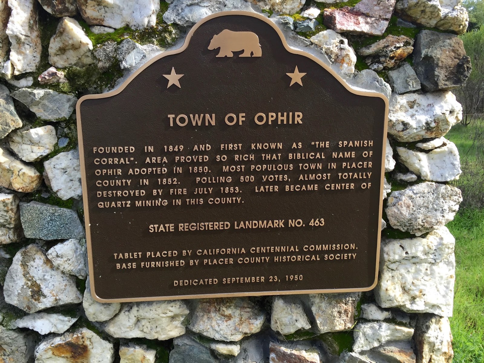
Staying with mining towns that don't exist any more, we next went to the Town of Ophir (CHL 463).

The plaque reads: Founded in 1849 as 'The Spanish Corral,' Ophir received its Biblical name in 1850 because of its rich placers. The most populous town in Placer County in 1852, polling 500 votes, Ophir was almost totally destroyed by fire in July 1853 but later became the center of quartz mining in the county.
We next headed to the City of Auburn (CHL 404).


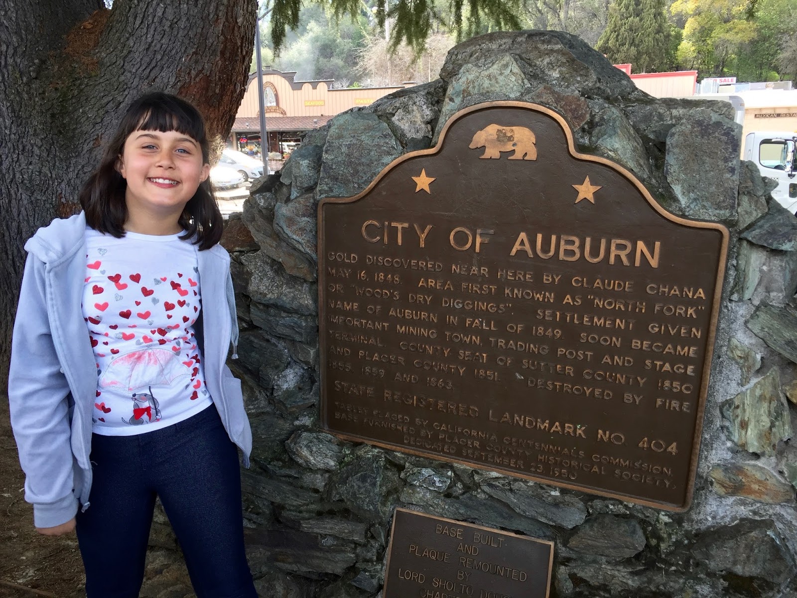
This cute little historic town has a huge statue dedicated to Claude Chana, whose discovery of gold lead to the founding of the town!


The plaque reads: Gold was discovered near here by Claude Chana on May 16, 1848. First known as 'North Fork' or 'Woods Dry Diggins,' the settlement was given the name Auburn in the fall of 1849. It soon became an important mining town, trading post, and stage terminal, and also became the county seat of Sutter County in 1850 and of Placer County in 1851. It was destroyed by fires in 1855, 1859, and 1863.

There were lots of plaques in Auburn-- this one particularly caught our eye about Sacagawea's son who spent some time in Auburn.

We had to get one more transcontinental railroad site in today-- so we visited The First Transcontinental Railroad Auburn (CHL 780-4).

This plaque was hidden under a bush on a very steep driveway.

The plaque reads: After an 11-month delay due to political opposition and lack of money, Central Pacific tracks reached Auburn May 13, 1865, and regular service began. Government loans became available when the railroad completed its first 40 miles, four miles east of here. With the new funds, Central Pacific augmented its forces with the first Chinese laborers, and work began again in earnest.

Right across from the plaque is a railroad depot with a cool statue out front to honor the Chinese workers who built so much of the railroad.

After a quick lunch break at a cute little deli in Auburn we were back on the road.

We hit the road again, this time to visit the Mountain Quarries Railroad Bridge (CHL 1051) which spans Placer and El Dorado Counties.

The plaque reads: This bridge, built to carry limestone from nearby quarries to the city of Auburn, was a very early use of reinforced concrete in railroad bridge construction and the largest such railroad bridge in California at the time it was built in 1912. The bridge was designed by John B. Leonard, who became one of California's most renowned pioneers in the design, engineering, and promotion of the use of reinforced concrete.

It was a fun little hike, with a spectacular view!

As we headed to our next CHL, we came to the town of Cool.

How COOL is this? Cool, California!!!!

This was just too much fun to pass up!

In the town of Cool we came to a site with no plaque, but lots of goats-- it is the Site of California's First Grange Hall (CHL 551).

If the plaque had been on this plinth, it would have said: Pilot Hill Grange No. 1, with 29 charter members-Master, F. D. Brown - Secretary A. J. Bayley-was organized August 10, 1870. The Grange hall, dedicated at this site on November 23, 1889, was built by Alcandor A. Bayley.

Next to the plinth there was a fenced off building which is the Bayley House (which the Grange Hall used to be next to). The most exciting thing about the property, was all the goats that came to say hello!

This is a better view of the Bayley house, which will hopefully be restored someday.

We saw the other end of the Coloma Road back in Sacramento at Sutter's Fort. Today we say the end of the Coloma Road (CHL 748) nearest Sutter's Mill.

The plaque read: Here in the valley of the Cul-luh-mah Indians, James W. Marshall discovered gold on January 24, 1848, in the tailrace of Sutter's sawmill. The old Coloma Road, opened in 1847 from Sutter's Fort to Coloma, was used by Marshall to carry the news of the discovery to Captain John A. Sutter. During the gold rush, it was used by thousands of miners going to and from the diggings. In 1849 it became the route of California's first stage line, established by James E. Birch.

We were now to the site that started the gold rush... CHL 530 Gold Discovery Site.

The plaque says: This rock monument marks site of John A. Sutter's saw mill in the tailrace of which James W. Marshall discovered gold, January 24, 1848, starting the great rush of argonauts to California. The Society of California Pioneers definitely located and marked site in 1924. Additional timbers and relics, including original tailrace unearthed in 1947, were discovered after property became state park. Marshall Monument overlooking this spot was erected following movement inaugurated in 1886 by Native Sons of the Golden West.

There was a gorgeous huge plinth by the water's edge, some reproductions of mining equipment,


and plaques indicating where things had been placed.

There was a really cool museum with lots of displays on the gold rush.


There is also another plaque outside of the building... and when we see a plaque we take a photo with it!

Up a winding hill we came to the Marshall Monument (CHL 143).

The state says: In 1887 the State of California purchased the site for a monument to commemorate James Marshall, who in 1848 discovered gold near Coloma. Marshall's discovery started the 'gold rush,' that westward trek of Argonauts that marked a turning point in California history. The figure of Marshall atop the monument is pointing to the place of discovery on the South Fork of the American River.


The statue of Marshall has him holding a gold nugget in one hand and pointing with the other to the place where he found gold.

There are lots of plaques all over the monument with lots of great information on it!


Our final site for the day was the Wakamatsu Tea and Silk Farm Colony (CHL 815).

The guidebook and the plaque both have information on this site:
The agricultural settlement of pioneer Japanese immigrants who arrived at Gold Hill on June 8, 1869-the only tea and silk farm established in California-had a promising outlook but failed tragically in less than two years. This was the initial Japanese-influenced agricultural attempt in California.
| |||||
Happily Libi is still enjoying visiting all of these sites, so we will continue on!  | |||||


0 comments:
Post a Comment