


Today we visited Tuolumne County. Just like when we visited Calaveras County last year, many of the sites we visited in Tuolumne County were gold-themed. We began our trek today in Soulsbyville (CHL #420), one of the early gold strikes in the county.

ECV had their plaque . . .

While the Bret Harte/Mark Twain Trail had their own. The fraternal organization E Clampus Vitus, or ECV, is super active up here in Gold Country. You can read more about ECV back in our Calaveras County travels HERE.
A few cool things about Soulsbyville: they have a little K-8 school where the school song is all about the history of the town (you can see it here) and in recent years a very rare duck called a smew was sighted here making it a destination for bird watchers.
A few cool things about Soulsbyville: they have a little K-8 school where the school song is all about the history of the town (you can see it here) and in recent years a very rare duck called a smew was sighted here making it a destination for bird watchers.

We've seen recurring themes among our landmarks: Spanish padre/explorer camped here, oil was first discovered here, gold was first discovered in this county here, lots of people passed through this pass here or crossed this river here, etc. The next site, Sonora Pass-Mono Road (CHL #422), is an example of another one of these important passageways--this one going across the Sierra Nevada mountain range.

This particular road connected two very important counties. It was completed in 1864 after it took a six horse team three weeks to make a round trip between Sonora and Bridgeport.

We find interesting place names along our travels. There's Bodfish, Caliente, and Havilah, all in Kern County that come to mind. Then there is the little town of Confidence, CA--population 50.

Speaking of Confidence, someone had the confidence--or rather the gall, to either destroy or remove an entire plaque and plinth from our next site: Cherokee (CHL #445). It's completely gone!

The crazy thing is here is a photo taken by blogger Mark Heringer just 14 months ago. It was just there last year!
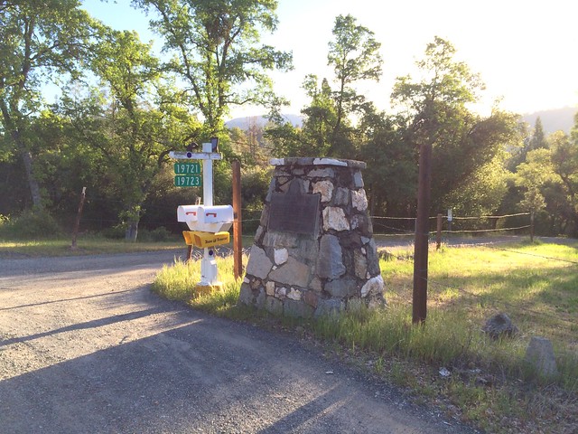
Here's our photo from today's travels--and the whole structure has vanished from its base. You can also see that the mailboxes have been moved about eight feet closer to the road. Very strange. Was it theft? Did some vehicle come by and plow into the structure? We called the Tuolumne County Visitors Bureau and they didn't know.

Was the plaque moved to another part of town (it's happened to other plaques we have searched for)? We cruised through the small town of Cherokee, even stopping at the local Indian casino (Black Oak Casino Resort) to see if perhaps the plaque was moved there. After all, the town of Cherokee was so named in honor of the Scott Brothers, descendants of the Cherokee tribe. The plaque has vanished, but the access road to the casino still bears the name of the brothers for whom the town was named.

We stopped for a moment to visit the former center of the old mining town of Tuolumne (CHL #407), which comes from a Native American word meaning "the people who dwell in stone houses." Tuolumne is not only the name of this historic town, but also a river flowing from the Sierras, as well one of the original 27 counties when California was first admitted to the Union in 1850.

Sonora is the county seat and at a population of 4,903 is the largest city in the county. Sonora is actually the only incorporated city in Tuolumne County, so being the largest city wasn't too difficult. Sonora is beautiful, and the crown jewel at the top of its sloping main corridor, Washington Street is our next site.

Built in 1859 and consecrated in 1870, St. James Episcopal Church (CHL #139) is the oldest Episcopal Church building in California.

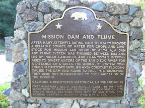
We know gold mining was popular around these parts. Later it was quartz mining. While the mining has subsided, one thing that's still going strong to this day is the logging industry. Our next site, Sawmill Flat (CHL #424), once played host to not one, but two sawmills. According to legend, it was here at Sawmill Flat that the famous Mexican bandit, Joaquin Murrieta (sometimes called the "Mexican Robin Hood", he served as the inspiration for the character Zorro), began his murderous spree as revenge for the rape and murder of his wife by white California settlers.

Here's the crazy thing: multiple locations in California claim to be the place where Joaquin Murrieta died. In this article from Sierra Nevada Geotourism (a National Geographic website), they claim Murrieta was killed right here at Sawmill Flat.

However, when we visited this site in Fresno County, they also claim to be the location of the shootout that ended Murrieta's life, at Cantua Creek or Arroyo de Cantua. History.com backs up that report as well. I know that a song can't be used as a definitive source, but according to the song (see YouTube video below), Murrieta was killed just outside Murphys, which is in Calaveras County. Sheesh!
The Contra Costa County Historical Society weighs in with a well-sourced article HERE where they too claim that Murrieta was shot down near what is today the junction of Interstate 5 and Highway 33 (in Coalinga, Fresno County). Finally, when you Google "where did Joaquin Murrieta die," you get this response: San Benito County. Seriously? San Benito County didn't even become a county until 1874. C'mon, Google!

Perhaps we will never know the true place of death for Joaquin Murrieta. One thing we do know, however, is how much fun it is to try out our new selfie stick for the first time on our travels!

Moving on now to perhaps the most fun and engaging stop on our travels today: Columbia (CHL #123)! The state of California has done a great job preserving this Gold Rush-era town, and today it makes up the Columbia State Historic Park.

There were musicians playing in the street.

A cool bookstore full of great old books from the 1800s, as well as great artifacts from the early days of our state.

This bookstore was Heather's favorite part of our visit!

After our visit to the bookstore, Libi got to dip candles for the first time!

Heather and I both remember doing this at Knott's Berry Farm as kids, so it was fun to see Libi get to do it for the first time.

Another first for Libi--she got to pan for gold!

Libi was eager to begin her search, but didn't really know where to begin.

Fortunately, historical reenactor John was happy to lend a hand and was awesome!

He carefully explained each step to Libi.

He showed her how to properly shake, dip, and swirl until she finally found some real gold in her pan--she got three whole flakes! You can't see it in this photo here, but you can see all the garnet stones she gathered.

Libi let me try, too!

Prospector John was so nice that he gave Heather a pan so she could try her luck as well.

Gold was discovered here in Columbia in 1850, and the population (like so many other towns of its kind) boomed dramatically following the news of the find.

After about eight years, boom turned to bust, but Columbia never became a ghost town. It was turned into a State Historic Park in 1945 so that families and fourth grade classes alike could see what life was like in a typical Gold Rush town.

Libi even got to dress up in period costume!

Our next stop was Springfield (CHL #432). Springfield was another gold mining town, but Springfield was unusual because it had a very active temperance society. In other words, Springfield was a dry town--quite unusual for Gold Country.

Just down the road a couple miles we came upon Shaw's Flat (CHL #395).

The original bell that called men to work and announced town meetings is right here!

The bartender in Shaw's Flat was brilliant! According to legend, he supplement his income by gathering up the gold dust lodged in the mud of his customers' boots that walked into his saloon.

Our final landmark of the day is Parrott's Ferry (CHL #438). Before bridges spanned large valleys, ferries were the way that settlers crossed rivers. Thomas Parrott owned this passage across the Stanislaus River.

We got our photo of Libi with the plaque first . . .

And then we decided to get Libi with the Stanislaus River in the background. This part of the Stanislaus River is now the north end of New Melones Lake, formed by the completion of the New Melones Dam in 1978.

In the shadow of the Parrott's Ferry Bridge is an abandoned car. Not quite sure how it got down there.

Below is the Stanislaus River looking south toward New Melones Lake. Despite the low level of the lake, it's still being used for recreation, as you can see from the boat speeding by.

Looking northeast up the Stanislaus River (photo below, Tuolumne County on the far bank and Calaveras County on the near bank) you can really see the effects of the drought.

Here are the effects of the drought on New Melones Lake in the last 1,000 days:

And finally here are Jeff Culver and I (and a little bit of Isaac's shoulder) on New Melones Lake two summers ago during one of our ManQuest adventures. You can definitely see that lake levels were already down back in 2013, but not nearly as low as they are now. Let's hope we get some serious rain/snow in the coming years.


0 comments:
Post a Comment