Today's adventures took us north and east of our home in Santa Clarita. We began our journey traveling up Highway 14 to Tehachapi. It was windy up there! Fitting, then, that our first historic site of the day should be adjacent to a wind farm.
Oak Creek Pass (CHL #97) was a gateway from the Mojave Desert to the San Joaquin Valley, used by Spanish missionaries and American pioneers alike. There seemed to be a common theme in Kern County today:
this site was used to get from one place to another or
somebody important passed through here.
Next up is the site of
Old Town Tehachapi (CHL #643). Again, a place where settlers and pioneers would pass through on their way from Southern California to the San Joaquin Valley.
Our next stop was pretty amazing: the
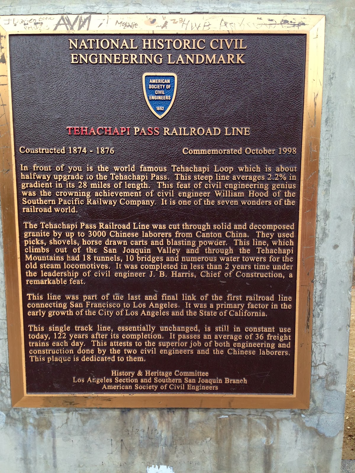
Tehachapi Loop (CHL #508).
The Tehachapi Loop is pretty amazing. It allows a train to climb a steep grade in a short amount of time. This photo that I took doesn't quite do it justice.
Here's a photo from Greg Loskorn that shows just how impressive the loop is. A long enough train can actually cross over itself as it ascends the grade.
Now, the American Society of Civil Engineers placed that beautiful plaque you saw above. In the copy, they claim that the Tehachapi Loop is one of the Seven Wonders of the Railroad World. This got me thinking: "Where are the other 6?" I scoured the internet looking for the list, and couldn't find it. So I tweeted the ASCE. As of the date of this posting (finally published on 2/17), they haven't responded. Does such a list really exist?
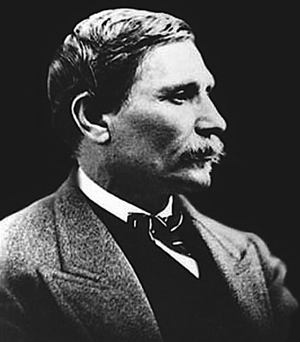
Our next stop was Bealville (CHL #741). Bealville is named for Edward Beale.
Edward Beale served in the Mexican-American War, received commissions from five different Presidents, and was the owner of the largest private landholding in the United States: Tejon Ranch.
Beale also convinced the US Army to establish
Fort Tejon, one of the sites we visited on one of our previous adventures.
The railroad was very important to this part of California, and we continued to see evidence of this as we followed the path of the railroad further north into Kern County.
The town of
Caliente (CHL #757) served as the construction headquarters for the Union Pacific railroad in the 1870s, and it is still had dozens of railroad workers all around in the present day.
As we continue north, gold mining becomes a more significant part of Kern County history. Here is an old gold mining town and former county seat:
Havilah (CHL #100).
As we descended from the mountains into the valley surrounding Lake Isabella, we entered the town of Bodfish. No historical markers here. I just like the name "Bodfish."
We finally got down into the valley, right near Lake Isabella. Here we found the
Campsite of Edward M. Kern (CHL #742). John C. Fremont's led the expedition into the area, and named the river for his topographer, Edward M. Kern.
The river was dammed in 1953 by the US Army Corps of Engineers. In 2006, the dam was considered too unstable to fill to maximum capacity, and so currently the Army Corps of Engineers won't allow it to fill above 60%. No problem now with the drought that has affected California now for the past five years.
In our travels throughout California, Lake Isabella is just one of many bodies of water affected by the drought. The water barely even reaches the bottom of the dam right now.
From the valley basin, we headed back up into the mountains, this time stopping at another bygone gold mining town:
Keyesville (CHL #98).
Maybe it's not so bygone after all? They had to put a sign prohibiting mining. Maybe there is still gold in them thar hills!
We traveled back around Lake Isabella, this time over to the west bank, to discover
Kernville (CHL #132), another long-gone ghost town. This plaque had to be moved in the 1950s. Why? Because the original location of Whiskey Flat/Kernville is now located at the bottom of Lake Isabella.
Here is the old Kernville Cemetery, final resting place for a number of Kern County's original residents.
Back up into the hills we went! We traveled Highway 155 from Lake Isabella through the southern Sierra Nevada mountains, and we actually got to play in the snow!
We finally got up and over our final mountain pass, and into Glennville, where we discovered the Glennville Adobe (CHL #495), the oldest house in Kern County.
As you can see, it is not currently inhabited.
The next stop on our journey was Lavers Crossing (CHL #672). David Lavers built a hotel and stage stop here in 1859, and was the local postmaster. In 1870, the population dwindled to the point where the post office was forced to close and relocate to nearby Glennville.
Across the road from the Lavers Crossing plaque was this farm. Libi loved seeing the horses!
Adjacent to the plaque (and our car) was another property, guarded by this dog. He didn't care too much for our being there, and expressed his displeasure at our trespass. We cautiously re-entered our car.
We got back on the road and continued south and west, headed back toward Bakersfield. We were running out of daylight, so we had to hurry. Next was the
Garces Baptismal Site (CHL #631). From the state: "Three miles north of this point was the site of the first recorded Christian baptism in the San Joaquin Valley. On May 23, 1776, Padre Francisco Garcés, earliest non-Indian in this area, baptized an Indian boy whom he called Muchachito at a Yokuts Rancheria in Grizzly Gulch."
Unfortunately, the plaque has been stolen. Libi expressed her disappointment.
Like I said, we were racing for daylight, but on the plus side the setting sun made for a beautiful scene on the farmlands of Kern County.
Our second-to-last stop was another stop on the Butterfield Stage Line:
Mountain House (CHL #589).
Is it really that slow around here in this part of Kern County? There are bullet holes in the plaque!
Final stop of the day was one more Butterfield stop: the
Posey Station of the Butterfield Overland Mail Lines (CHL #539). We saw our very
first Butterfield site back in downtown Los Angeles. Sadly, there was another stolen plaque, but happily, we visited our last site before we lost daylight!
On our next travels, we are headed to Calaveras County--Gold Country!


0 comments:
Post a Comment