We knew that we wanted to do one more day of NorCal sites before we returned home, so we set the ambitious goal of completing Contra Costa County today.
Our first site is one we hope to return to with Jammy and Granpa to do the full mine tour, the Mount Diablo Coal Field (CHL 932).
In this area there were 12 major mines and five towns (all of which are gone except for some buildings that the park has preserved). 4 million tons of coal was mined here making it the largest coal mining district in California for over 50 years! The do have a tour where you can don hardhats and flashlights and explore one of the mines, but sadly we didn't have time to do that today. We will totally be back to further explore the grounds and the mines.
Our second site was on a corner in a lovely neighborhood, the
Captain Pedro Fages Trail (CHL 853).
Fages was trying to explore more of the land east of the San Fransisco Bay so he set off with Father Crespi, 14 soldiers, a muleteer, and a Native American servant. The cool thing about this expedition is that Father Crespi kept a daily journal so we can follow along on their journey (and we've already seen one of his sites in Kern County). The expedition camped near here on March 31, 1772 and shortly after became the first Europeans to climb Mount Diablo (see the next post) to view the Sacramento River Delta.
We next made the windy, bike-ridden ascent up Mount Diablo (CHL 905).
We weren't sure if we would find any plaques at the summit-- but we found plaques, a visitors center and a gift shop! Score!!
Mount Diablo has been a sacred spot to Native Americans, a surveying site for land surveys of Northern California, and the site of a popular bike race.
One cool thing about the peak is that inside the visitors center they allow you to stand directly on the highest point of the mountain...
with a cut out in the floor. Libi got to stand directly on the top of Mount Diablo!
We were also pleased to find a state plaque here.
The mountain is home to lots of flora and fauna...
but the view is the real draw!
We even got a few family shots while we were there.
Another thrilling thing that happened on the mountain was that we saw a Hawaii license plate-- bringing us ever closer to finding all 50 on our trip this summer.
Our next site, the
Joaquin Moraga Adobe (CHL 509) wasn't nearly as fun-- there was no plaque and we couldn't get anywhere near the site.
Somewhere on this property, behind these trees we believe still exists the adobe house that was originally built in 1841. It is the oldest of five adobes still remaining in the county.
The next plaque was located on a major street outside of a Chase bank. The Castro Home (CHL 356) was built by the Castro family on land called Rancho San Pablo.
Sadly the adobe was destroyed by fire in 1956.
There is also apparently a plaque at the northern boundary of the Rancho, but we didn't find out about it until we were home, so we will have to try and locate it at a later visit.
The
Richmond Shipyards District (CHL 1032) is home to the brand-new Rosie the Riveter Museum.
The shipyards here covered over 880 acres and in 1944 they were the largest yards in the world!
During the WWII period of 1941-1945 they built 747 ships in the yards including 519 Liberty Ships (about a quarter of the U.S. production of that model)!
So why Richmond and Rosie together, you may ask? From 1941-1943 they hired 90,000 new workers and since so many men were off fighting the war many of the jobs went to women.
Libi tried her hand a being a riveter, but she said it was too loud-- guess we will have to find another career for her.
If you know any women who worked at factories or shipyards during WWII, they are looking for their stories and/or artifacts.
We didn't find a plaque at the shipyards or the museum, so we decided to see if there was one at the Rosie monument just a short drive away.
We didn't find a plaque there either, but it was well worth a short visit.
They do have a little memorial tile here for Henry J. Kaiser who constructed the shipyards here.
Since we couldn't find a plaque, the sign on the side of the freeway and lots of cool Rosie the Riveter memories will have to do.
Sometimes signs lead you to follow random roads to nowhere-- and sometimes you should just follow the directions your wife printed for you. As we drove to the Light Stations of California (Thematic), East Brother Light Station (CHL 951) we relearned this lesson :)
This is the oldest wood-frame lighthouse on the West Coast that is still fully operational. It was built in 1873 to help guide boats through the San Pablo and San Francisco Bays. There is an entire online book about the lighthouse that you can check out
here.
It is now operating as a bed and breakfast to help pay for up-keep of the site, you can make your reservations
here.
This next stop frustrates me just a bit-- you see as the planner and navigator for the trip I use a variety of resources to plan our trips. During my research I couldn't find a listing for a plaque at this site-- sadly as we were about an hour away I found the listing for the state plaque for the
Site of Giant Powder Company-- Point Pinole (CHL 1002-1). We will hopefully return for the plaque at a later time, but enough of my moping-- on with the history of the site:
The Giant Powder Company was the first company in the US to produce dynamite. They moved their factory here in 1892 due to the isolated location (they had already had major explosions in the factories located in San Francisco and Berkeley). The explosives made here were used in mining, dam and big construction projects in the West. They stopped production in 1960.
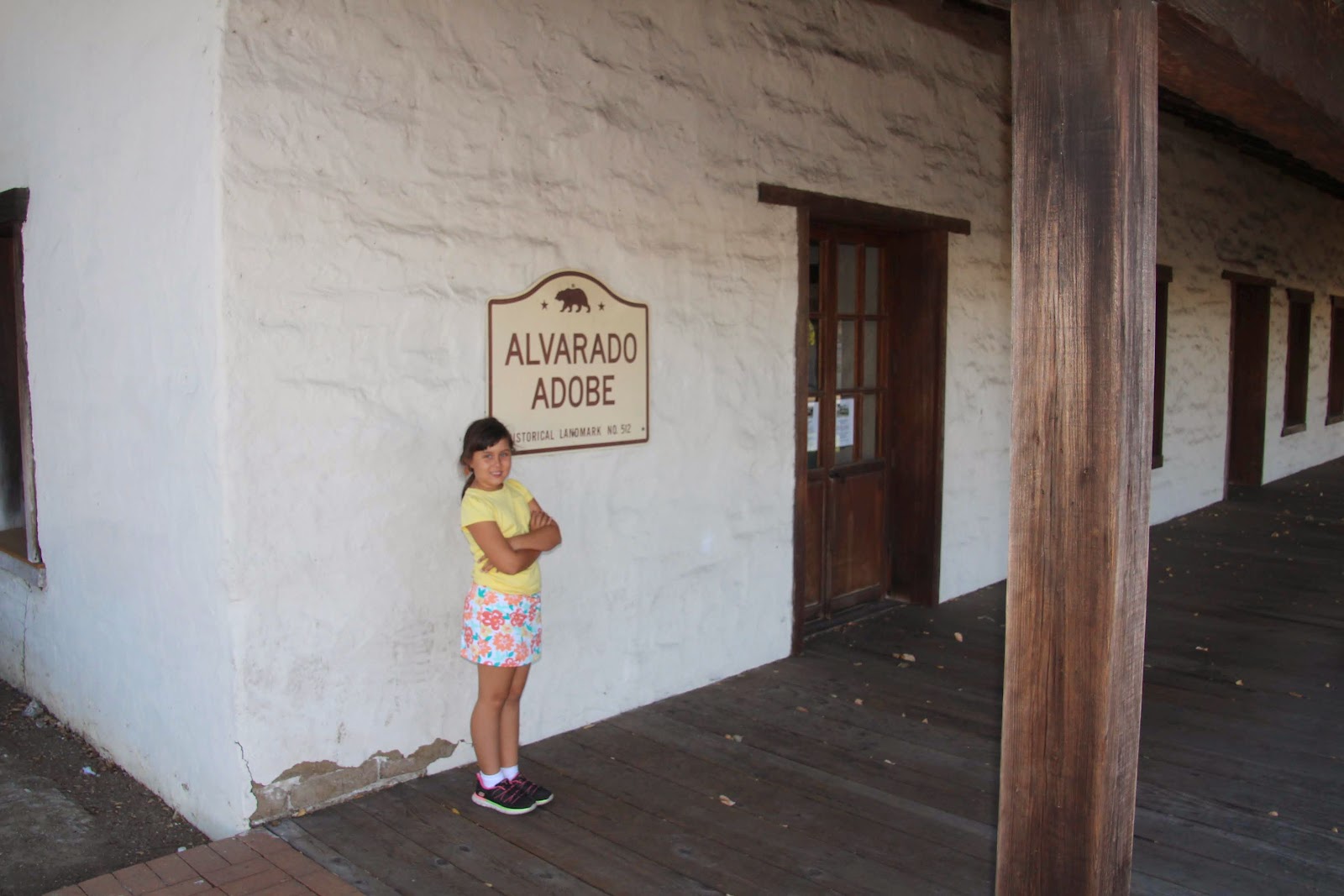
The
Alvarado Adobe (CHL 512) was our next stop. This adobe was built in 1842 for Dona Gabriela Berryessa de Castro. When she passed away in 1851 it was passed down to her daughter who was married to Juan Bautista Alvarado, the governor of California from 1836-1842. It appears that they do tours here, but we arrived too late for that.
Our next site proved a bit tricky to locate. In the small town of Crockett we were looking for the
Old Homestead (CHL 731), we knew there was a state plaque, but we couldn't find it.
We could see what we thought was the house, but a cursory inspection didn't show us the plaque.
We did take a photo by the sign, just in case we couldn't find it...
However, we persevered and crashed a wedding reception that was happening on the grounds to get the photo with the plaque.
Ron found the wedding party on-line and made a donation towards their honeymoon to thank them for allowing us to "visit" their reception.
The house was the first American home built in the town of Crockett. Many of the wood you see is original and it was brought to the site around the Horn. It was built in 1867 by Thomas Edwards Sr. To see some photos from inside the house you can click
here.
Our next two plaques are located at the same location, but sadly we were too late to walk the park grounds.
The first is the
Vicente Martinez Adobe (CHL 511). If we had been able to get onto the grounds, I think the adobe is still standing-- we will have to return here to find out.
This adobe was built in 1849 by Vicente Martinez. Over the years it had many owners, the most famous of which was Dr. John Strentzel, father-in-law of John
Muir. Muir's eldest daughter Wanda and her family lived here and John Muir would visit to play with his grandchildren.
That brings us to the
John Muir Home (CHL 312)-- the home that John shared with his wife Luisa. They had two daughters here, who gave them 10 grandchildren!
John Muir has been called the patron saint of the American wilderness for his passionate work in preservation of all the beauty our land has to offer, he also co-founded the Sierra Club. There are countless areas in California and beyond named for him-- he was truly influential as evidenced by his presence on the California state quarter!
We will absolutely be back to further explore this area.
Our next site was a bit odd-- it is simply a plaque on the side of the road across from an industrial center-- here is the
Site of the Murder of Dr. John Marsh (CHL 722).
John Marsh was quite a colorful character according to some sources and a "hero neglected by historians" according to the John Marsh Historic Trust. In a nutshell: He was a man who studied with many doctors but never received a formal degree in medicine. He is reported as the first person to practice western medicine in Los Angeles, but charged exorbitant rates. He had a son with his mistress, but had to abandon him and his mistress (who was pregnant with a second child) due to some shady dealings with Native Americans. His mistress died in childbirth and he only reconnected with his first son about a month before his death. He was the first American to build a home in Contra Costa County. He built a large stone home which is in the process of being restored and turned into a
state park and had a huge cattle ranch. "Dr" Marsh was well-known for charging high fees to his patients, but paying terrible wages to his workers-- as we was traveling from Martinez to San Fransisco he was ambushed by some of the vaqueros who worked for him who disputed the wages they were paid. According to the plaque, the "ruffians" murdered him on this spot on September 24, 1856. It doesn't sound to me like John Marsh was a hero, but he is a very colorful California pioneer!
Our next site was supposed to have a state plaque a short drive away from the actual site, however when we arrived there we found that it was gone! Here is where the plaque for the
Don Fernando Pacheco Adobe (CHL 455) should be.
Happily the site was a short drive away and we got a photo here! This is site of an adobe completed in 1843 by Don Fernando Pacheco. It has been restored and has been used as a restaurant, offices and the Contra Costa's Horseman's Association.
Our final and 15th stop for the day was the
Don Salvio Pacheco Adobe (CHL 515).
This is supposedly the first building built in the valley by Don Salvio Pacheco in 1835.
Don Salvio was very generous to donate the lands around the adobe to refugees of the earthquake-flood of 1868. This is another site that is open to the public, but we arrived too late. We will have to return here as well-- our list of placed to return to is growing rapidly!
This completes another county on Libi's California Adventures!


0 comments:
Post a Comment