


Our first stop was Warring Park (CHL #624) in Piru. Warring Park is one of many California landmarks that records an encounter between Europeans and Native Americans, this time it's between Spanish explorer (and later California governor) Gaspar de Portolá with the Piru Indians.


Adjacent to Warring Park is the old Piru Bridge. Built in 1902, Piru Bridge is an abandoned through-truss railroad bridge now used in movie shoots.


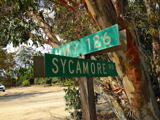
Next stop on our travels was Sycamore Tree (CHL #756). Sycamore Tree used to have a plaque, but now I am listing as "plinth, no plaque."


Some legends swirling around Sycamore Tree say it's haunted. That story is documented here by photographer Vivian Krug:
https://www.facebook.com/media/set/?set=a.667900079906467.1073741853.113475825348898&type=3
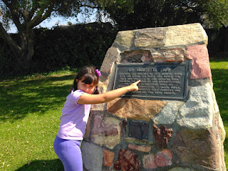
The plaque, which has apparently been missing since May 2013, at one time said:
In 1846 General John C. Frémont passed this sycamore tree on his way to sign a treaty with General Andrés Pico to secure California for annexation to the United States. The tree has served as a resting place, a polling place, a temporary post office, and an outdoor chapel.
John C. Frémont, it is worth noting, was also the first Republican Party candidate for President of the United States. He lost to James Buchanan in 1856. The Republicans would win four years later, however, with the election of Abraham Lincoln.

Our next landmark is located in Santa Paula, and is listed as Portolá Expedition (CHL #727).

Libi was pretty excited when she saw what is almost the exact spelling of our last name (our version of "Ippolito" is spelled with two P's). "Ipólito is a Spanish variation of Saint Hippolytus, a 4th-century Roman bishop and Catholic martyr. Again, this location is another one of those "encounter points" between Europeans and local Indians.

Next up was the Union Oil Company Building (CHL #996). We had no idea what we were exploring, and we just assumed that if the building was still standing, that it would be closed on Sundays. Nope. It's a working museum, and it's open seven days a week. You can check out their website here: http://www.oilmuseum.net/

It was an impressive representation of the history of oil production in California.


A full size replica of an 1890s oil derrick, all indoors!


I wish gas still cost this much! I'm guessing this is a price from the late 1960s or early 1970s (pre-oil embargo).


The final exhibit was all about fracking and the future of oil discovery. Hmmm . . . things are starting to get a little political now.


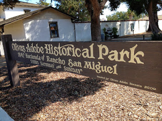
We probably spent a solid 45 minutes in the California Oil Museum, and we were starting to get hungry. We decided we would eat in Ventura, so one more stop and then it will be time for lunch. We made it to the west end of Highway 126, and arrived at Olivas Adobe (CHL #115).
Here is Libi's interpretation of the California bear.


The interesting thing about the Olivas Adobe is you get to see artifacts from two different time periods in history. There is the Olivas family history from old California, while it was still under Mexican rule. Later, you can see evidence of the time Major Max Fleischmann lived here with his family after his service in the balloon signal corps in World War I. Major Fleischmann made his fortune with Fleischmann Yeast (the standard for home bread bakers since 1876).


We went to lunch at the Ventura Spaghetti Company (delicious!) where I took advantage of the $4.95 Spaghetti Sunday special. From there, it was already a little later in the day than we expected, and we contemplated simply heading home after lunch. I'm glad we didn't, because here was our next stop:

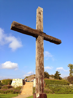
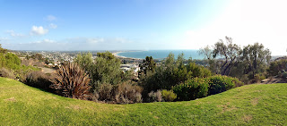
It was the most beautiful visit of the day, Junipero Serra's Cross (CHL #113). Father Serra put a cross high up on the hill above Mission San Buenaventura (his final California mission) as a signal to travelers from faraway that a mission was near. This wooden cross has been replaced three different times since the founding of the mission in 1782. The current cross has been there since 1941. You can read about the full history of the cross here: http://www.serracrosspark.org/history.html
The views from Serra Cross Park were beautiful today.

This was my most beautiful view: my two girls.

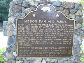
We came down the hill from Serra Cross Park and had a decision to make. Where to next? We had a few different options, but we were losing daylight, so we decided instead of trying to visit the mission (we will save Mission San Buenaventura for another day), we would venture out just a little further and head toward Ojai. On the way to Ojai are the remnants of the waterway that carried fresh water to the mission: the San Buenaventura Mission Aqueduct (CHL #114-1).

The largest remaining remnant where you can actually see the water ducts is just behind a fence on private property. I didn't feel like trespassing (today) so this is the closest we got. There is a laminated paper marker that is starting to wear away attached to the fence. Note that it lists the Aqueduct as "Landmark No. 28," but this is because Ventura County has a separate numbering system from the State of California.

About a hundred yards away is a bronze marker next to a smaller aqueduct artifact.

We kept driving north and east on Highway 33, which merged into Highway 150 east. We drove through Casitas Springs (Johnny Cash's home for about seven years) on our way to Ojai. No official CHLs in Ojai, although we are interested in a future visit to Thomas Aquinas College back in the hills above Santa Paula.
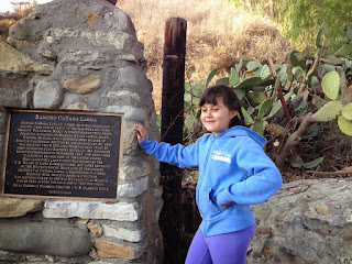
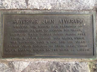
We re-entered Santa Paula, and re-connected with Highway 126 headed east back toward Santa Clarita. Our final landmark of the day was Rancho Camulos (CHL #553).
Rancho Camulos is rich in culture! The museum is only open on Saturdays (we visited on Sunday), but it seems there has been a lot going on on this property lately. Last Saturday was a "Zeva Farewell" tour. NCIS fans (we don't watch the show) would know that the season premiere of the show was filmed right here at Rancho Camulos. Next Saturday is Trafalgar Day, where Napoloeonic War re-enactors will get all dressed up and perform for visitors. In addition to the deep connection to Californio ranch culture of the 1800s, the "pop culture" connection of Rancho Camulos goes all the way back to Helen Hunt Jackson's 1884 novel Ramona, much of which was set here at the Rancho. Ramona was apparently all the rage in late-1800s America. The town of Ramona (in San Diego County) was originally going to be called "Nuevo," but was renamed "Ramona" because the popularity of the novel. D.W. Griffith (Hollywood pioneer and producer/director of Birth of a Nation) shot his film version of Ramona, starring Mary Pickford, right here at Rancho Camulos in 1910. They host Ramona Days each fall (we missed it two weeks ago) where they do a dramatic interpretation of the story. We'll definitely have to come back for Ramona Days.


And so the sun sets on another fun day of California Historical Landmarks, now bringing our total up to 18 (out of a total of 1,103). Next weekend: downtown Los Angeles!


0 comments:
Post a Comment