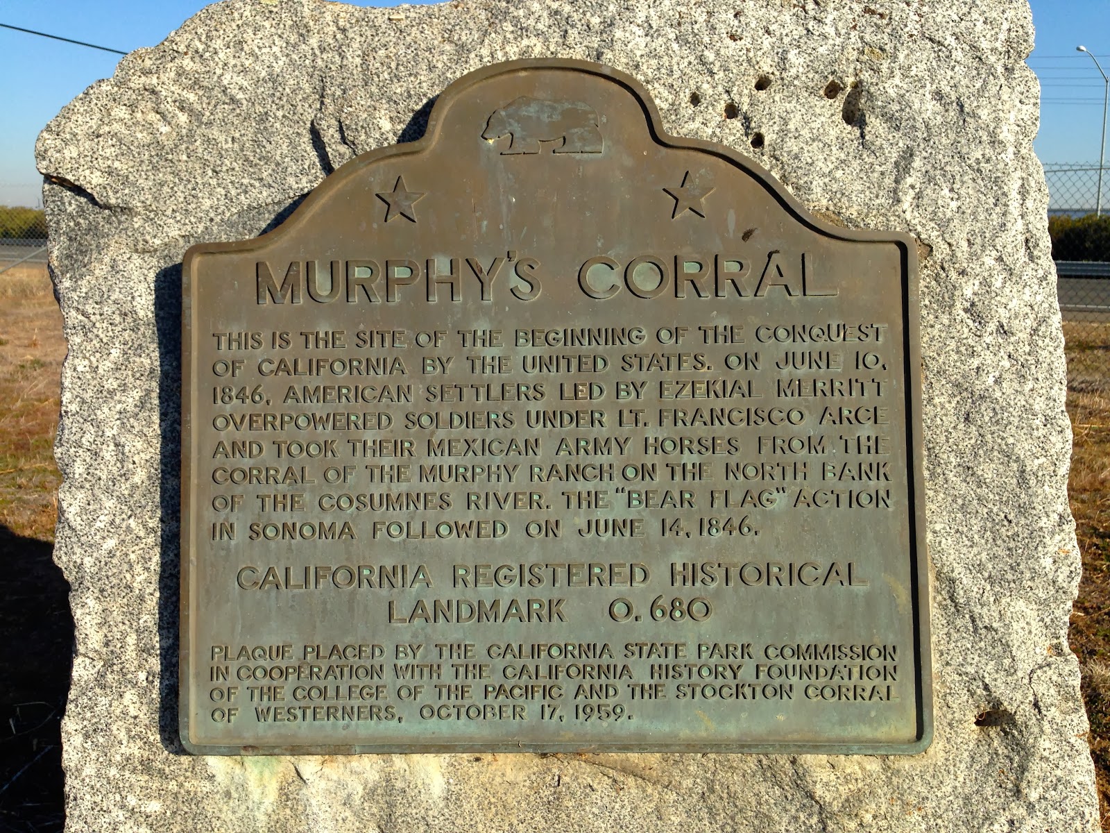
Today we explored East Sacramento County. We headed up Highway 99 to our first stop: Murphy's Ranch (CHL #680).
The plaque says "Murphy's Corral," but the official State of California website says Murphy's Ranch, so that's what we're going with. A corral was involved, however. In fact, this is the site where American settlers, led by Ezekiel Merritt (plaque spells it "Ezekial," but every historical piece I have found online spells it "Ezekiel"), overpowered Mexican soldiers and stole their horses from the corral at Murphy's Ranch on June 10, 1846. From what I've read so far, Merritt was a drunk and an illiterate. But he was apparently given command of this small group of settlers by Captain John C. Frémont, and four days later Merritt helped lead the "
Bear Flag Revolt" in Sonoma. This revolt would give California her independence from Mexico, and would eventually pave the way for US annexation. We'll explore more on the story of the Bear Flag action when we get to Sonoma.
Next stop on our journey takes us to the campus of Sac State.
Having the plaque in the middle of a school campus (we've had one of these before already) makes it a bit more difficult because we have to do a little more exploring. We consider it a success if we get "as close as we possibly can under the circumstances." If the plaque is behind a locked gate, then we get as close as we possibly can, take whatever photo we can, and move on. We believed that with a little searching we could find this plaque, so we kept looking. Eventually, due to my wife's expert navigation, we found the plaque for
Five Mile House--Overland Pony Express Route in California (CHL #697).

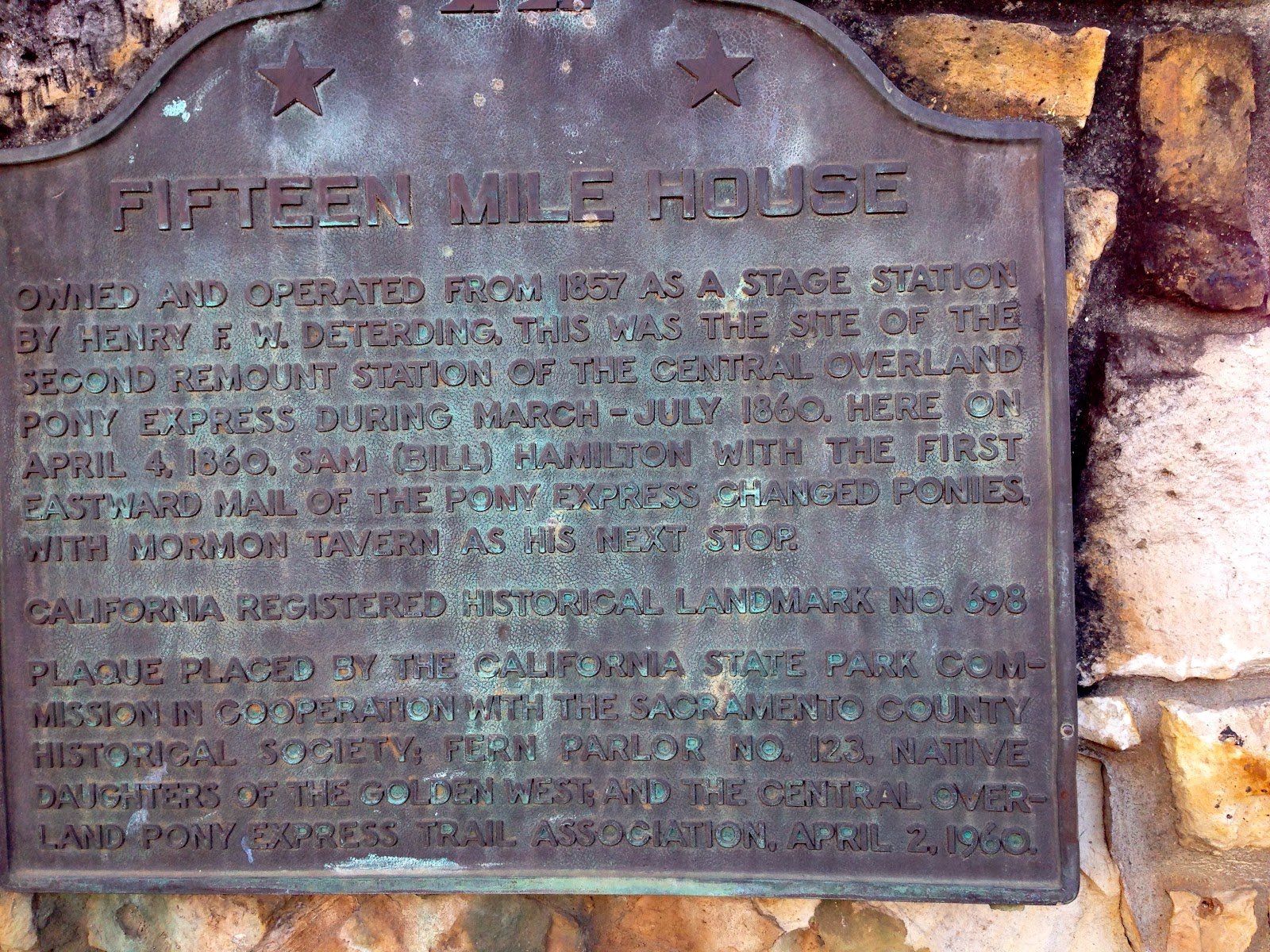
From the State of California: "Departing at 2:45 a.m. from the Alta Telegraph Co. in Sacramento, rider Sam (Bill) Hamilton carried the first mail of the Central Overland Pony Express eastward on April 4, 1860. Quickly changing ponies at the Five Mile House, he sped on to the next stop at Fifteen Mile Station."
We had a couple cemeteries to visit today, so we tracked down our first one. This doesn't look like a cemetery. In fact, it's now Sutter Middle School. Nevertheless, this is the site for the
New Helvetia Cemetery (CHL #592).
According to
findagrave.com, there were over 5,000 bodies buried here, some of whom were the founders of Sacramento, that were interred here for nearly 100 years when their remains were moved to different cemeteries to make room for the school. As a teacher, I don't know if I would be so keen to teach on land that used to be a cemetery. Hmmmm.
Yup, there's the blacktop of Sutter Middle School. Right over what used to be the final resting place for thousands.
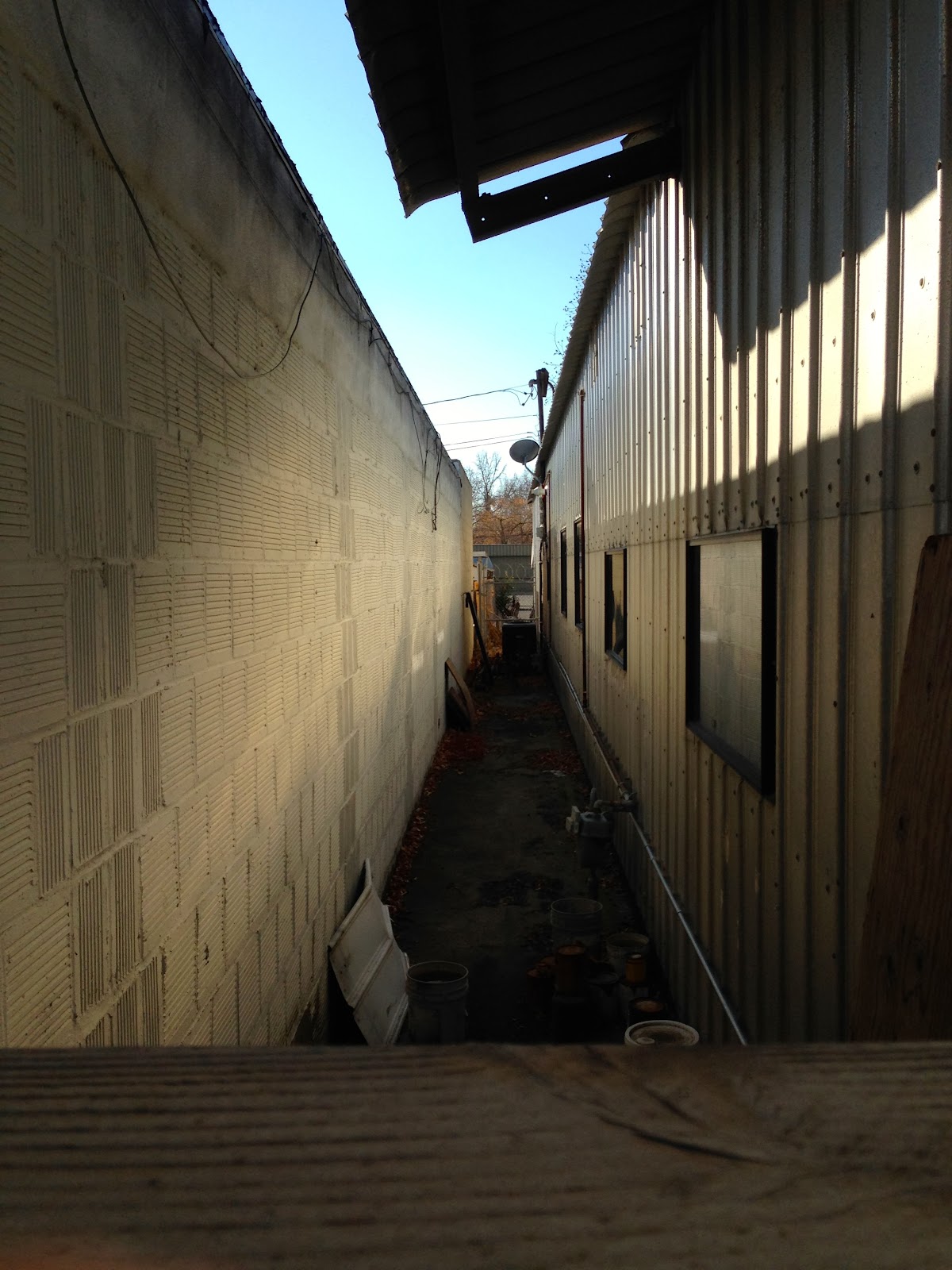
Well, speaking of sad, converted cemeteries, here is the site of the first Jewish cemetery in California:
Chevra Kaddisha: Home of Peace Cemetery (CHL #654-1). It's a strip mall now, in between Club Raven nightclub and Smolich & Smolich, attorneys-at-law.
This narrow passage in between the two buildings (photo below) is where 3230 J Street in Sacramento should be. Libi has a sad face in the photo above to indicate her displeasure that two cemeteries in a row have been disturbed.
On to happier locations. Here is
Sutter's Landing (CHL #591).
John Sutter, of course, is a big deal here in Sacramento. This is the site where Captain Sutter landed his ship after coming up the Sacramento River delta from Yerba Buena (now San Francisco). It was shortly after this landing that be built the famous for that bears his name.
Our next landmark took us to another golf course.
We headed out just north of the clubhouse to find this landmark: First Transcontinental Railroad: Western Base of the Sierra Nevada (CHL #780-8).
From the state: "On January 12, 1864, President Abraham Lincoln decreed that the western base of the Sierra Nevada began where the Central Pacific Railroad crossed Arcade Creek. The hardships of railroad construction through mountains resulted in increased government subsidies that gave the company impetus to finish the transcontinental railroad."
The "ECV" on the top of this compass gives us another clue as to how active the service organization
E Clampus Vitus is around these parts. Perhaps I should apply for membership.
Sadly, our next landmark is yet another "934"--we've seen a lot on this trip. This 934 the
Temporary Detention Camps for Japanese-Americans: Sacramento Assembly Center (CHL #934).
This is another example of a temporary detention area used in WWII until more permanent facilities (like Manzanar) could be constructed. Unlike many of the others, this site did not get a state plaque. It only has a couple of small, private plaques.
"It was 4 a.m. in Sacramento when a 100 gun salute shattered the quiet. People not planning on getting up early that morning never forgot it. But it was a memorable day for other reasons, too. It was when electric power arrived in Sacramento over 22 miles of line from the new Folsom Powerhouse."
- San Francisco Chronicle July 13, 1895
22 miles may not seem like a big deal today, but back in 1895 it was huge. The
Folsom Powerhouse (CHL #633) was the first place in the United States to produce long-distance hydroelectric power.
Horatio Gates Livermore traveled west from Maine to purchase land in the area. His original plan was to harvest pine trees and send them down the American River. To harness the logs, he had a plan to build a dam. The water power from the dam could also be used to power mills along the river, just like the ones he saw in New England in places like Lowell, Massachusetts. He convinced the state of California to not only build their new prison in Folsom (San Quentin was getting too crowded, and Rocklin was another candidate), but to also provide prison labor to build both the dam and the powerhouse. The quarry inside FSP provided all the stone for the dam, so those images of inmates pounding rocks were actually quite true in the case of Folsom. Naturally we had the Johnny Cash Pandora station playing on our drive here.

Then a problem arose: Horatio Gates Livermore died . His sons, Horatio P. and Charles E. Livermore took over, but instead of a traditional water mill, they decided to convert the plans into a hydroelectric plant.
We had a delightful older gentleman as our docent to guide us through the history of the powerhouse. Throughout our travels, we have encountered a number of retirees who love sharing the history of their community with tourists and travelers like ourselves. Maybe I'll be doing tours like this when I retire.
The machinery inside the powerhouse was big and, well, powerful. It made for some great photos. All of these were just taken with my iPhone 5.
All the bricks used to build the powerhouse were recycled from a local train station that had been decommissioned.
The Folsom Powerhouse was definitely the highlight of our day, but we still had four more sites to visit as the sun was setting.
Our next two sites took us to quant downtown Folsom. Here is the Terminal of California's First Passenger Railroad (CHL #558). This railroad only ran 22 miles (the distance from Folsom to Sacramento) and was completed in 1856.
Our next site in downtown was the
Folsom-Overland Pony Express Route in California (CHL #702).
While there was a railroad connecting Folsom to Sacramento, the railroad was still a couple decades away from connecting to the rest of the United States. That's why the Pony Express was so important during this site's brief tenure as a stop along the network.
One of the original hitching posts still exists on the site, which was only in use from 1860 to 1861.
We loved downtown Folsom, and this is one of those places that we definitely want to return to. Snooks Candies was just one of many things we liked about the town!
Quaint.
Historical!
OK, we're losing daylight, so it's on to our next site:
Prairie City (CHL #464).
Prairie City was one of many gold rush boom towns that disappeared when the gold did. The site of Prairie City today has simply been consumed by the suburban sprawl of Folsom.
Here was another disturbing monument to what was once a cemetery, but whose residents were relocated when the land was needed for other purposes.
Our next stop took us to the shores of Lake Natoma and it was another landmark that figured prominently in the Gold Rush history of this region:
Coloma Road-Nimbus Dam (CHL #746). From the state: "Alder Springs, south of this point, marks the old Coloma Road, running between Sutter's Fort and Coloma. Established in 1847, this road was used by James W. Marshall in January 1848 to bring the first gold from Sutter's Mill to the fort. Later, traveled by thousands to and from the diggings, it became the route of California's first stageline, established in 1849 by James E. Birch."
We were upset to see that the plaque had been stolen! Notice Libi's sad face in the above photo. Heather had to take a quick restroom break, so she courageously handed off her very nice camera to Libi, who handled it like a pro.
Our last historic site of the day brought us to the Sacramento suburb of Rancho Cordova.
This site brings us full circle for the day. We began the day with the "Five Mile House" Pony Express station and we end our day now with the
Fifteen Mile House (CHL #698).
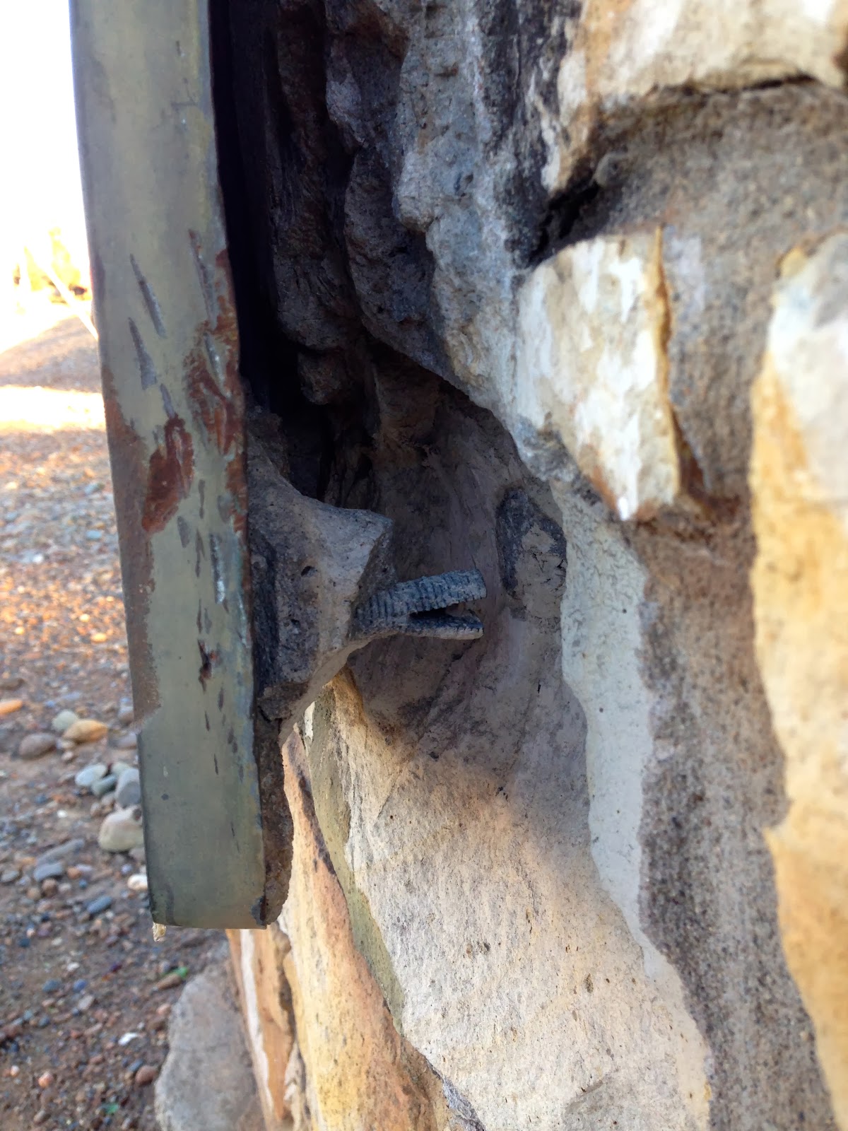
If you have been following our travels for a while now, you know how many sad markers and monuments we have come upon. Here is one that looks like thieves started to pry out of the plinth.
Perhaps the police rolled up to the scene before they could claim their ill-gotten prize. It's so important for us to preserve our state's historic treasures!